Columbia Lake fishing map is included in Lakes and Rivers of British Columbia nautical charts folio. It is available as part of iBoating : Canada Marine & Fishing App (now supported on multiple platforms including Android, iPhone/iPad, MacBook, and Windows(tablet and phone)/PC based chartplotter. ).
With our Lake Maps App, you get all the great marine chart app features like fishing spots, along with Columbia Lake depth map. The fishing maps app include HD lake depth contours, along with advanced features found in Fish Finder / Gps Chart Plotter systems, turning your device into a Depth Finder. The Columbia Lake Navigation App provides advanced features of a Marine Chartplotter including adjusting water level offset and custom depth shading. Fishing spots and depth contours layers are available in most Lake maps. Lake navigation features include advanced instrumentation to gather wind speed direction, water temperature, water depth, and accurate GPS with AIS receivers(using NMEA over TCP/UDP). Autopilot support can be enabled during ‘Goto WayPoint’ and ‘Route Assistance’.
Now i-Boating supports Fishing Points in Columbia Lake.
Have more questions about the Nautical Chart App? Ask us.
Fishing Info for Columbia Lake
The Columbia River (Upper Chinook: Wimahl or Wimal; Sahaptin: Nch’i-Wàna or Nchi wana; Sinixt dialect swah'netk'qhu) is the largest river in the Pacific Northwest region of North America. The river rises in the Rocky Mountains of British Columbia, Canada. It flows northwest and then south into the U.S. state of Washington, then turns west to form most of the border between Washington and the state of Oregon before emptying into the Pacific Ocean. The river is 1,243 miles (2,000 km) long, and its largest tributary is the Snake River. Its drainage basin is roughly the size of France and extends into seven US states and a Canadian province. The fourth-largest river in the United States by volume, the Columbia has the greatest flow of any North American river entering the Pacific. The Columbia has the 36th greatest discharge of any river in the world. The Columbia and its tributaries have been central to the region's culture and economy for thousands of years. They have been used for transportation since ancient times, linking the region's many cultural groups. The river system hosts many species of anadromous fish, which migrate between freshwater habitats and the saline waters of the Pacific Ocean. These fish—especially the salmon species—provided the core subsistence for native peoples. The first documented European discovery of the Columbia River occurred when Bruno de Heceta sighted the river's mouth in 1775. In the late 18th century, a private American ship became the first non-indigenous vessel to enter the river; in 1792, William Robert Broughton of the British Royal Navy commanding the HMS Chatham as part of the Vancouver Expedition, navigated past the Oregon Coast Range into the Willamette Valley. In the following decades, fur-trading companies used the Columbia as a key transportation route. Overland explorers entered the Willamette Valley through the scenic, but treacherous Columbia River Gorge, and pioneers began to settle the valley in increasing numbers. Steamships along the river linked communities and facilitated trade; the arrival of railroads in the late 19th century, many running along the river, supplemented these links. Since the late 19th century, public and private sectors have extensively developed the river. To aid ship and barge navigation, locks have been built along the lower Columbia and its tributaries, and dredging has opened, maintained, and enlarged shipping channels. Since the early 20th century, dams have been built across the river for power generation, navigation, irrigation, and flood control. The 14 hydroelectric dams on the Columbia's main stem and many more on its tributaries produce more than 44 percent of total U.S. hydroelectric generation. Production of nuclear power has taken place at two sites along the river. Plutonium for nuclear weapons was produced for decades at the Hanford Site, which is now the most contaminated nuclear site in the United States. These developments have greatly altered river environments in the watershed, mainly through industrial pollution and barriers to fish migration.
More on Wikipedia...Popular fish species in this lake include Bull trout, Rainbow trout and White sturgeon.
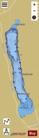
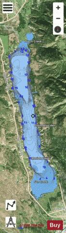
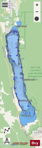
Columbia Lake Fishing Map Stats | |
| Title | Columbia Lake |
| Scale | 1:24000 |
| Districts | East Kootenay |
| Nearby Cities | Invermere, Kimberley, Cranbrook, Elkford, Banff, Canmore |
| Area * | 5971.24 acres |
| Shoreline * | 26.64 miles |
| Min Longitude | -115.88 |
| Min Latitude | 50.16 |
| Max Longitude | -115.82 |
| Max Latitude | 50.30 |
| Edition Label 1 | |
| Edition Label 2 | |
| Edition Label 3 | |
| Id | CA_BC_columbia_lake_bc |
| Country | CA |
| Projection | Mercator |
| * some Stats may include nearby/connecting waterbodies | |
|