Inga Lake fishing map is included in Lakes and Rivers of British Columbia nautical charts folio. It is available as part of iBoating : Canada Marine & Fishing App (now supported on multiple platforms including Android, iPhone/iPad, MacBook, and Windows(tablet and phone)/PC based chartplotter. ).
With our Lake Maps App, you get all the great marine chart app features like fishing spots, along with Inga Lake depth map. The fishing maps app include HD lake depth contours, along with advanced features found in Fish Finder / Gps Chart Plotter systems, turning your device into a Depth Finder. The Inga Lake Navigation App provides advanced features of a Marine Chartplotter including adjusting water level offset and custom depth shading. Fishing spots and depth contours layers are available in most Lake maps. Lake navigation features include advanced instrumentation to gather wind speed direction, water temperature, water depth, and accurate GPS with AIS receivers(using NMEA over TCP/UDP). Autopilot support can be enabled during ‘Goto WayPoint’ and ‘Route Assistance’.
Now i-Boating supports Fishing Points in Inga Lake.
Have more questions about the Nautical Chart App? Ask us.
Fishing Info for Inga Lake
Inga Lake is a freshwater lake located in north-eastern British Columbia. It is located between Fort Nelson and Fort St. John on the Alaska Highway. It is at mile 91 of the Alaska Highway, and features a maintained free campsite. Outhouses, and large camping spots are featured as well as quad, and dirt bike trails. It is a popular fishing destination, which is stocked annually with Rainbow trout. A spawning channel project has been underway at Inga since 1997. The purpose of the channel is educational in nature and to prevent diploid (2N) rainbows from becoming spawnbound. Suckers are far and away the most abundant fish in this lake. It is not the easiest spot to find, as only a small green sign indicates its whereabouts.
More on Wikipedia...Popular fish species in this lake include Catostomidae and Rainbow trout.
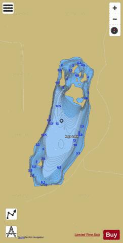
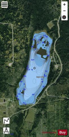
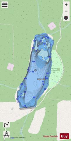
Inga Lake Fishing Map Stats | |
| Title | Inga Lake |
| Scale | 1:6000 |
| Districts | Peace River |
| Nearby Cities | Fort St. John |
| Area * | 135.14 acres |
| Shoreline * | 3.89 miles |
| Min Longitude | -121.65 |
| Min Latitude | 56.61 |
| Max Longitude | -121.64 |
| Max Latitude | 56.62 |
| Edition Label 1 | |
| Edition Label 2 | |
| Edition Label 3 | |
| Id | CA_BC_inga_lake_631868 |
| Country | CA |
| Projection | Mercator |
| * some Stats may include nearby/connecting waterbodies | |
|