Kakwa Lake fishing map is included in Lakes and Rivers of British Columbia nautical charts folio. It is available as part of iBoating : Canada Marine & Fishing App (now supported on multiple platforms including Android, iPhone/iPad, MacBook, and Windows(tablet and phone)/PC based chartplotter. ).
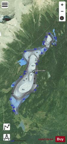
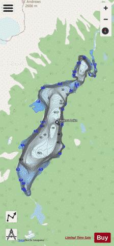
With our Lake Maps App, you get all the great marine chart app features like fishing spots, along with Kakwa Lake depth map. The fishing maps app include HD lake depth contours, along with advanced features found in Fish Finder / Gps Chart Plotter systems, turning your device into a Depth Finder. The Kakwa Lake Navigation App provides advanced features of a Marine Chartplotter including adjusting water level offset and custom depth shading. Fishing spots and depth contours layers are available in most Lake maps. Lake navigation features include advanced instrumentation to gather wind speed direction, water temperature, water depth, and accurate GPS with AIS receivers(using NMEA over TCP/UDP). Autopilot support can be enabled during ‘Goto WayPoint’ and ‘Route Assistance’.
Now i-Boating supports Fishing Points in Kakwa Lake.
Have more questions about the Nautical Chart App? Ask us.
Fishing Info for Kakwa Lake
The Kakwa River is a tributary of the Smoky River in western Alberta, Canada. The river is named for Kakwa, the Cree word for porcupine. Porcupines are abundant in Kakwa Provincial Park and Protected Area. Tourism along the river revolves around bull trout fishing and white water rafting. Kakwa Falls (54°06′33″N 119°55′25″W / 54.10913°N 119.92350°W) are developed in the course of the river, over a 30-metre (98 ft) high ledge formed by an outcrop of the Cadomin Formation. The area was designated a protected wildland (Kakwa Wildland Park). It can be accessed through the forestry road network south of Highway 666, approximately 35 kilometres (22 mi) south of Two Lakes Provincial Park.
More on Wikipedia...Popular fish species in this lake include Bull trout.
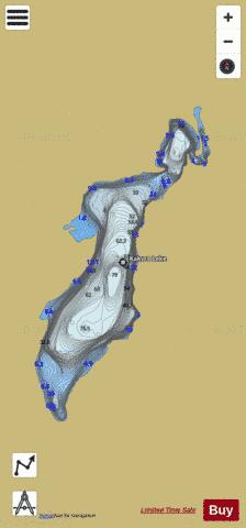
Kakwa Lake Fishing Map Stats | |
| Title | Kakwa Lake |
| Scale | 1:12000 |
| Districts | Peace River |
| Area * | 916.39 acres |
| Shoreline * | 9.86 miles |
| Min Longitude | -120.18 |
| Min Latitude | 54.00 |
| Max Longitude | -120.14 |
| Max Latitude | 54.04 |
| Edition Label 1 | |
| Edition Label 2 | |
| Edition Label 3 | |
| Id | CA_BC_kakwa_lake_bc |
| Country | CA |
| Projection | Mercator |
| * some Stats may include nearby/connecting waterbodies | |
|