Little Lillooet Lake fishing map is included in Lakes and Rivers of British Columbia nautical charts folio. It is available as part of iBoating : Canada Marine & Fishing App (now supported on multiple platforms including Android, iPhone/iPad, MacBook, and Windows(tablet and phone)/PC based chartplotter. ).
With our Lake Maps App, you get all the great marine chart app features like fishing spots, along with Little Lillooet Lake depth map. The fishing maps app include HD lake depth contours, along with advanced features found in Fish Finder / Gps Chart Plotter systems, turning your device into a Depth Finder. The Little Lillooet Lake Navigation App provides advanced features of a Marine Chartplotter including adjusting water level offset and custom depth shading. Fishing spots and depth contours layers are available in most Lake maps. Lake navigation features include advanced instrumentation to gather wind speed direction, water temperature, water depth, and accurate GPS with AIS receivers(using NMEA over TCP/UDP). Autopilot support can be enabled during ‘Goto WayPoint’ and ‘Route Assistance’.
Now i-Boating supports Fishing Points in Little Lillooet Lake.
Have more questions about the Nautical Chart App? Ask us.
Fishing Info for Little Lillooet Lake
Little Lillooet Lake, historically also Tenas Lake is a lake in the Lower Lillooet Country located to the south of Pemberton, British Columbia, Canada, turning off highway 99 on the FSR to 33 km. along the course of the Lillooet River, which continues southwards beyond it to Harrison Lake. Still formally a separate lake, historically construction of a small dam to enable steamer service to , which lay at the head of Lillooet Lake, its northern neighbour and parent wateflow, during the construction of the Lakes Route during the Fraser Canyon Gold Rush. "Tenas" or "tenass" in Chinook Jargon means "small" or "child" and was an alternate name for this lake, at the south end of which was , which connected by the Douglas Road to Port Douglas which was at the head of river navigation from the Strait of Georgia and served as a port for the Interior of British Columbia. The Indian reserve community of Samahquam is located near its southern end at 33 km and further south is the Indian Reserve Skatin at 47 km near the Tsek hotsprings at 44 km.
More on Wikipedia...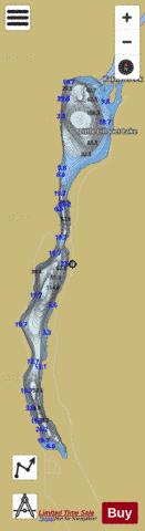
Little Lillooet Lake Fishing Map Stats | |
| Title | Little Lillooet Lake |
| Scale | 1:12000 |
| Districts | Fraser Valley |
| Nearby Cities | Pemberton, Whistler, Squamish, Lillooet, Lions Bay, Mission, Vancouver, Aldergrove |
| Area * | 887.08 acres |
| Shoreline * | 12.37 miles |
| Min Longitude | -122.55 |
| Min Latitude | 50.05 |
| Max Longitude | -122.52 |
| Max Latitude | 50.12 |
| Edition Label 1 | |
| Edition Label 2 | |
| Edition Label 3 | |
| Id | CA_BC_little_lillooet_lake_22611 |
| Country | CA |
| Projection | Mercator |
| * some Stats may include nearby/connecting waterbodies | |
| |||||||||||||||||||||||||||||||||||||||||||||||||||||||||||||||||||||||||||||||||||||||||||||||||||||||
|