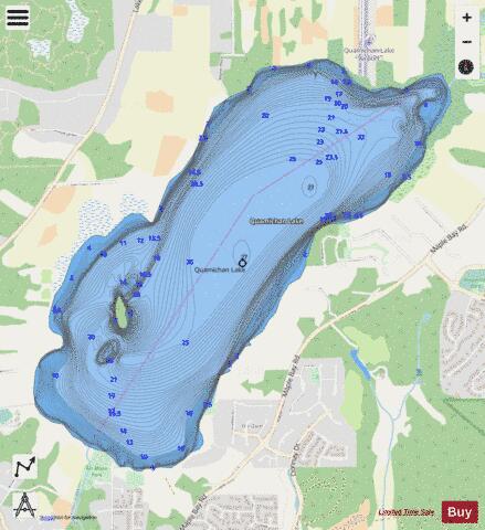
Quamichan Lake fishing map is included in Lakes and Rivers of British Columbia nautical charts folio. It is available as part of iBoating : Canada Marine & Fishing App (now supported on multiple platforms including Android, iPhone/iPad, MacBook, and Windows(tablet and phone)/PC based chartplotter. ).
With our Lake Maps App, you get all the great marine chart app features like fishing spots, along with Quamichan Lake depth map. The fishing maps app include HD lake depth contours, along with advanced features found in Fish Finder / Gps Chart Plotter systems, turning your device into a Depth Finder. The Quamichan Lake Navigation App provides advanced features of a Marine Chartplotter including adjusting water level offset and custom depth shading. Fishing spots and depth contours layers are available in most Lake maps. Lake navigation features include advanced instrumentation to gather wind speed direction, water temperature, water depth, and accurate GPS with AIS receivers(using NMEA over TCP/UDP). Autopilot support can be enabled during ‘Goto WayPoint’ and ‘Route Assistance’.
Now i-Boating supports Fishing Points in Quamichan Lake.
Have more questions about the Nautical Chart App? Ask us.
Fishing Info for Quamichan Lake
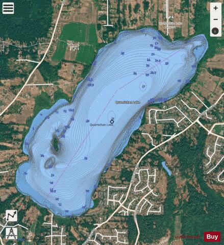
Quamichan Lake is a lake in the Cowichan Valley region of Vancouver Island, British Columbia, Canada, located three kilometres to the northeast of the City of Duncan. Quamichan Lake and its sister Somenos Lake were created 11,000 years ago by receding glaciers. Both lakes contribute to Cowichan River. Quamichan Lake's outflow is Quamichan Creek which joins with Somenos Creek, the outflow from Somenos Lake, which flows to Cowichan River. The Cowichan Watershed Board identifies a common set of conditions for both shallow lakes: * excessive nutrient loading from the farms and homes which surround the lakes * insufficient "flushing" in summer due to reduced inflows and truncated outflows * increased plant growth ("algae-blooms"), and * eutrophication (reduced oxygen as the vegetation decomposes) * intensified warming In autumn 2016, the lake's algae received public attention after news coverage of its killing at least four dogs.
More on Wikipedia...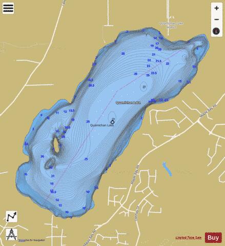
Quamichan Lake Fishing Map Stats | |
| Title | Quamichan Lake |
| Scale | 1:12000 |
| Districts | Cowichan Valley |
| Nearby Cities | Crofton, Duncan, Cowichan Bay, Chemainus, Cobble Hill, Shawnigan - Mill Bay, Ladysmith, Cedar, Lake Cowichan, Victoria |
| Area * | 714.13 acres |
| Shoreline * | 5.43 miles |
| Min Longitude | -123.68 |
| Min Latitude | 48.79 |
| Max Longitude | -123.64 |
| Max Latitude | 48.81 |
| Edition Label 1 | |
| Edition Label 2 | |
| Edition Label 3 | |
| Id | CA_BC_quamichan_lake_bc |
| Country | CA |
| Projection | Mercator |
| * some Stats may include nearby/connecting waterbodies | |
| ||||||||||||||||||||||||||||||||||||||||||||||||||||||||||||||||||||||||||||||||||||||||||||||||||||||||
|