Slocan Lake fishing map is included in Lakes and Rivers of British Columbia nautical charts folio. It is available as part of iBoating : Canada Marine & Fishing App (now supported on multiple platforms including Android, iPhone/iPad, MacBook, and Windows(tablet and phone)/PC based chartplotter. ).
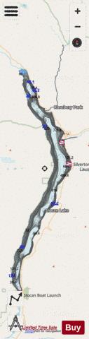
With our Lake Maps App, you get all the great marine chart app features like fishing spots, along with Slocan Lake depth map. The fishing maps app include HD lake depth contours, along with advanced features found in Fish Finder / Gps Chart Plotter systems, turning your device into a Depth Finder. The Slocan Lake Navigation App provides advanced features of a Marine Chartplotter including adjusting water level offset and custom depth shading. Fishing spots and depth contours layers are available in most Lake maps. Lake navigation features include advanced instrumentation to gather wind speed direction, water temperature, water depth, and accurate GPS with AIS receivers(using NMEA over TCP/UDP). Autopilot support can be enabled during ‘Goto WayPoint’ and ‘Route Assistance’.
Now i-Boating supports Fishing Points in Slocan Lake.
Have more questions about the Nautical Chart App? Ask us.
Fishing Info for Slocan Lake
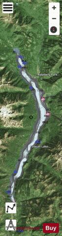
Slocan Lake is a lake in the Slocan Valley of the West Kootenay region of the Southeastern Interior of British Columbia, Canada. it is drained by the Slocan River, which flows south from the lake's foot at Slocan City through the Slocan Valley to South Slocan, British Columbia, where that river meets the Kootenay River a few miles above its confluence with the Columbia. It is fed by Bonanza Creek, which comes down the pass from Summit Lake, beyond which is the town of Nakusp on Upper Arrow Lake. In addition to Slocan City (officially now a "village", but usually referred to locally by its old name of Slocan City to distinguish it from Slocan Park and South Slocan), other towns and communities on the lake include the twin communities of New Denver and Silverton, midway up the lake's eastern shore, Rosebery slightly north of them at the mouth of Wilson Creek, and Hills at the lake's north end. To the west of the lake is the Valhalla Range (or "the Valhallas"), most of which is enshrined in Valhalla Provincial Park. The mountains to the east of Slocan Lake were the focus of the silver rush known as "the Silvery Slocan", during which steamboats and railways penetrated the Kootenay Range east of the lake to Sandon, the "capital" of the rush and the destination of three railways, two from the direction of Slocan Lake via Carpenter Creek, the other via Retallack Pass from Kaslo on Kootenay Lake. The 1902 discovery of zinc in the area also aroused interest and excitement. BC Highway 6 follows the eastern shore of Slocan lake from Hills to Slocan City and down the Slocan River from there. The Canadian Pacific rail line from Nakusp via Bonanza Pass now dead-ends at Rosebery Slip, on Slocan Lake, but originally ran into Sandon.
More on Wikipedia...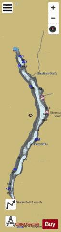
Slocan Lake Fishing Map Stats | |
| Title | Slocan Lake |
| Scale | 1:24000 |
| Districts | Central Kootenay |
| Nearby Cities | Nelson, Nakusp, Castlegar, Salmo, Trail - Fruitvale, Rossland |
| Area * | 17219.11 acres |
| Shoreline * | 75.03 miles |
| Min Longitude | -117.49 |
| Min Latitude | 49.77 |
| Max Longitude | -117.34 |
| Max Latitude | 50.12 |
| Edition Label 1 | |
| Edition Label 2 | |
| Edition Label 3 | |
| Id | CA_BC_slocan_lake_179968 |
| Country | CA |
| Projection | Mercator |
| * some Stats may include nearby/connecting waterbodies | |
|