Stave Lake fishing map is included in Lakes and Rivers of British Columbia nautical charts folio. It is available as part of iBoating : Canada Marine & Fishing App (now supported on multiple platforms including Android, iPhone/iPad, MacBook, and Windows(tablet and phone)/PC based chartplotter. ).
With our Lake Maps App, you get all the great marine chart app features like fishing spots, along with Stave Lake depth map. The fishing maps app include HD lake depth contours, along with advanced features found in Fish Finder / Gps Chart Plotter systems, turning your device into a Depth Finder. The Stave Lake Navigation App provides advanced features of a Marine Chartplotter including adjusting water level offset and custom depth shading. Fishing spots and depth contours layers are available in most Lake maps. Lake navigation features include advanced instrumentation to gather wind speed direction, water temperature, water depth, and accurate GPS with AIS receivers(using NMEA over TCP/UDP). Autopilot support can be enabled during ‘Goto WayPoint’ and ‘Route Assistance’.
Now i-Boating supports Fishing Points in Stave Lake.
Have more questions about the Nautical Chart App? Ask us.
Fishing Info for Stave Lake
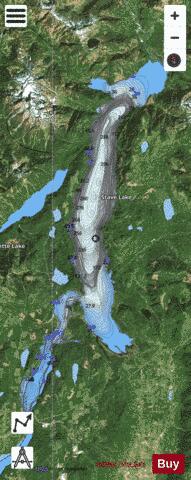
Stave Lake is a lake and reservoir for the production of hydroelectricity in the Stave River system, located on the northern edge of the District of Mission, about 65 km (40 mi) east of Vancouver, British Columbia, Canada. The main arm of the lake is about 20 km (12 mi) long from north to south and its southwest arm, ending at Stave Falls Dam near Stave Falls, is about 9.5 km (5.9 mi) long. The total area of the lake currently is about 55 square kilometres (21 square miles). Prior to construction of the dam, the lake was about one-third the size of its current main arm. The Stave River, the traditional territory of the , a vanished Halqemeylem-speaking Coast Salish people related to today's Sto:lo, was a productive salmon river. Huge red cedar trees grew in the valley and these drew sawmilling and cedar shingle interests, notably , whose mill was a mile above the damsite. The lower portion of the Stave is called Hayward Lake, formed by Ruskin Dam and formerly a canyon similar to Capilano and Lynn Canyons, and at its head in the grounds of the one-time community of worker's housing, there is a recreation area there and the beginning of a lakeside trail using the right-of-way of a railway line.
More on Wikipedia...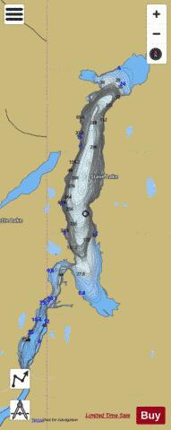
Stave Lake Fishing Map Stats | |
| Title | Stave Lake |
| Scale | 1:24000 |
| Districts | Fraser Valley |
| Nearby Cities | Mission, Abbotsford, Aldergrove East, Aldergrove, Chilliwack, Cultus Lake, Harrison Hot Springs, Kent, Rosedale, White Rock |
| Area * | 13971.85 acres |
| Shoreline * | 64.22 miles |
| Min Longitude | -122.37 |
| Min Latitude | 49.23 |
| Max Longitude | -122.22 |
| Max Latitude | 49.46 |
| Edition Label 1 | |
| Edition Label 2 | |
| Edition Label 3 | |
| Id | CA_BC_stave_lake_1036 |
| Country | CA |
| Projection | Mercator |
| * some Stats may include nearby/connecting waterbodies | |
| ||||||||||||||||||||||||||||||||||||||||||||||||||||||||||||||||||||||||||||||||||||||||||||||||||||||||
|