Holmes Lake fishing map is included in New Brunswick Fishing Maps nautical charts folio. It is available as part of iBoating : Canada Marine & Fishing App (now supported on multiple platforms including Android, iPhone/iPad, MacBook, and Windows(tablet and phone)/PC based chartplotter. ).
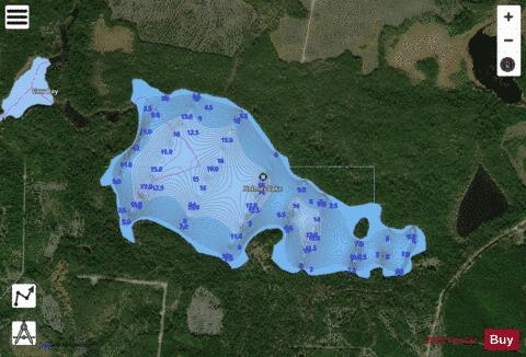
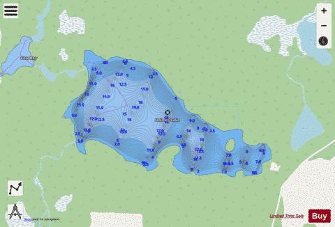
With our Lake Maps App, you get all the great marine chart app features like fishing spots, along with Holmes Lake depth map. The fishing maps app include HD lake depth contours, along with advanced features found in Fish Finder / Gps Chart Plotter systems, turning your device into a Depth Finder. The Holmes Lake Navigation App provides advanced features of a Marine Chartplotter including adjusting water level offset and custom depth shading. Fishing spots and depth contours layers are available in most Lake maps. Lake navigation features include advanced instrumentation to gather wind speed direction, water temperature, water depth, and accurate GPS with AIS receivers(using NMEA over TCP/UDP). Autopilot support can be enabled during ‘Goto WayPoint’ and ‘Route Assistance’.
Now i-Boating supports Fishing Points in Holmes Lake.
Have more questions about the Nautical Chart App? Ask us.
Fishing Info for Holmes Lake
Holmes Lake is a Canadian lake in Northumberland County, New Brunswick. Holmes Lake is one of several large lakes forming the headwaters of the Little Southwest Miramichi River. It was named in 1884 for the first lumberman who had worked the area The lake was long the exclusive fishery of the Pratt family of New York. After being introduced to the area by longtime guide , George Dupont Pratt constructed the log camps at the lake in 1909. Ownership of the camps later passed to his son Sherman Pratt, co-founder of Marineland. The Pratt family leased the fishing rights on this lake and the headwaters of the Little Southwest Miramichi River from the provincial government. Sherman Pratt was the founder of the Grenville Baker Boys Club (of Locust Valley, New York), and allowed the use of the Pratt Camp as a summer camp for its members, approximately thirty boys each summer.
More on Wikipedia...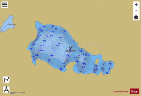
Holmes Lake Fishing Map Stats | |
| Title | Holmes Lake |
| Scale | 1:12000 |
| Nearby Cities | Saint-Quentin |
| Area * | 303.49 acres |
| Shoreline * | 4.24 miles |
| Min Longitude | -66.62 |
| Min Latitude | 46.94 |
| Max Longitude | -66.59 |
| Max Latitude | 46.96 |
| Edition Label 1 | |
| Edition Label 2 | |
| Edition Label 3 | |
| Id | CA_NB_holmes_nb |
| Country | CA |
| Projection | Mercator |
| * some Stats may include nearby/connecting waterbodies | |
| ||||||||||||||||||||||||||||||||||||||||||||||||||||||||||||||||||||||||||||||||||||||||||||||||||||||||||||||||||||||||||||||||||||||||||||
|