Mississippi Lake fishing map is included in Ontario Lakes nautical charts folio. It is available as part of iBoating : Canada Marine & Fishing App (now supported on multiple platforms including Android, iPhone/iPad, MacBook, and Windows(tablet and phone)/PC based chartplotter. ).
With our Lake Maps App, you get all the great marine chart app features like fishing spots, along with Mississippi Lake depth map. The fishing maps app include HD lake depth contours, along with advanced features found in Fish Finder / Gps Chart Plotter systems, turning your device into a Depth Finder. The Mississippi Lake Navigation App provides advanced features of a Marine Chartplotter including adjusting water level offset and custom depth shading. Fishing spots and depth contours layers are available in most Lake maps. Lake navigation features include advanced instrumentation to gather wind speed direction, water temperature, water depth, and accurate GPS with AIS receivers(using NMEA over TCP/UDP). Autopilot support can be enabled during ‘Goto WayPoint’ and ‘Route Assistance’.
Now i-Boating supports Fishing Points in Mississippi Lake.
Have more questions about the Nautical Chart App? Ask us.
Fishing Info for Mississippi Lake
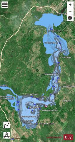
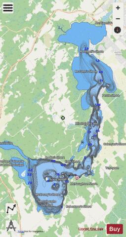
Mississippi Lake is a lake in Lanark County in Ontario, Canada. Ontario's Mississippi River flows northeast and north through the lake. Several small creeks including Cranberry Creek, McCrearys Creek, and McGibbon Creek drain into the lake from adjoining forest and agricultural land. The lake is distinctive for having one side (to the north) that is part of the Canadian shield, while the other is mostly limestone. The lake is a remnant of the old Champlain Sea, which flooded eastern Ontario at the end of last ice age. The former shoreline of the sea can still be traced inland from the north shore of the lake. European settlement of the lake basin began ca. 1816 as settlers moved north of the Rideau into areas such as Franktown. Between the 1860s and 1920s, there were steamboats linking Carleton Place to Innisville. The lake has two large and provincially significant wetlands. The larger occurs at the west end of the lake; here the Mississippi River enters the lake through the Innisville wetland, which is also one of the largest wetlands in Lanark County, and is designated an Area of Natural and Scientific Interest. Included within its boundaries is The Mississippi Lake National Wildlife Area. This wetland has large areas of silver maple swamp, flooded only in the spring, and, lower on the shore, important areas of marsh and aquatic vegetation. The western shore of the lake, including Kinch Bay, Code Bay and King Bay, also supports a diverse wetland which ranges from silver maple swamp to large areas of aquatic plants. Loons, bald eagles, osprey and herons are frequently sighted in these habitats. The ospreys and herons also breed inland from the lake, for example in the nearby Scotch Corners Wetland. The provincially significant Blanding's turtle is known from the lake; its long-term survival likely depends upon sufficient nesting areas. Eels were once abundant, but hydroelectric dams downstream have all but eliminated this species from the lake and the watershed.
More on Wikipedia...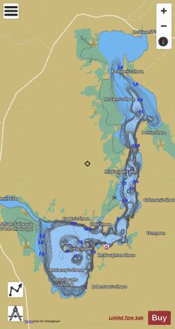
Mississippi Lake Fishing Map Stats | |
| Title | Mississippi Lake |
| Scale | 1:24000 |
| Districts | Lanark |
| Nearby Cities | Carleton Place, Almonte, Perth, Smiths Falls, Kanata, Richmond, Arnprior, Constance Bay, Ottawa - Gatineau, Kemptville |
| Area * | 6053.09 acres |
| Shoreline * | 42.03 miles |
| Min Longitude | -76.24 |
| Min Latitude | 45.01 |
| Max Longitude | -76.15 |
| Max Latitude | 45.13 |
| Edition Label 1 | |
| Edition Label 2 | |
| Edition Label 3 | |
| Id | CA_ON_V_103381168 |
| Country | CA |
| Projection | Mercator |
| * some Stats may include nearby/connecting waterbodies | |
|