Gibson Lake fishing map is included in Ontario Lakes nautical charts folio. It is available as part of iBoating : Canada Marine & Fishing App (now supported on multiple platforms including Android, iPhone/iPad, MacBook, and Windows(tablet and phone)/PC based chartplotter. ).
With our Lake Maps App, you get all the great marine chart app features like fishing spots, along with Gibson Lake depth map. The fishing maps app include HD lake depth contours, along with advanced features found in Fish Finder / Gps Chart Plotter systems, turning your device into a Depth Finder. The Gibson Lake Navigation App provides advanced features of a Marine Chartplotter including adjusting water level offset and custom depth shading. Fishing spots and depth contours layers are available in most Lake maps. Lake navigation features include advanced instrumentation to gather wind speed direction, water temperature, water depth, and accurate GPS with AIS receivers(using NMEA over TCP/UDP). Autopilot support can be enabled during ‘Goto WayPoint’ and ‘Route Assistance’.
Now i-Boating supports Fishing Points in Gibson Lake.
Have more questions about the Nautical Chart App? Ask us.
Fishing Info for Gibson Lake
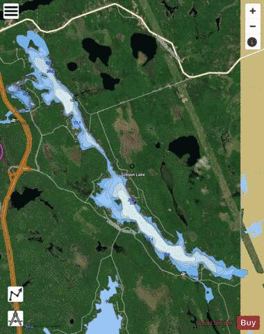
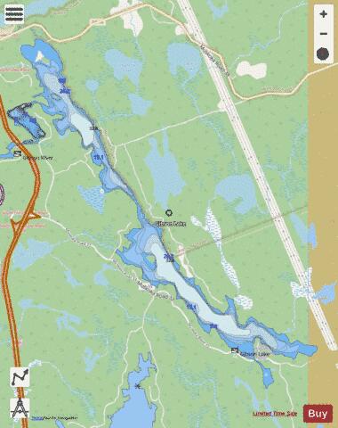
Gibson Lake is a lake in Georgian Bay Township, District Municipality of Muskoka, Ontario, Canada. It is located 45 minutes north of the city of Barrie, and is accessed by Hwy 400 interchange # 174, just north of Six Mile Lake. Gibson Lake borders on the Wahta Mohawk Territory. The lake is 7 kilometres (4.3 mi) long, and flows into Georgian Bay via the . The lake comprises two sections with the narrows connecting the North end to the South end. The southern areas of the lake are popular with cottagers from southern Ontario. The first cottagers purchased property here in the 1950s when the land was originally subdivided. There are presently 200 families on the lake with an increasing number of permanent residents. The north-east side of the lake is dominated by the Sahanatien Native Mohawk reserve which has seen much development in recent years. Many of the cottages on the north-east side are built on land leased from Wahta Mohawk families, and accessed by privately maintained roads. On February 7, 2005 Chief Blaine Commandant of the Wahta Mohawks, the Honourable Andy Scott, Minister of Indian Affairs and Northern Development, and the Honourable Michael Bryant, Ontario Minister Responsible for Native Affairs announced the settlement of a land claim dating back to 1918. The settlement consisted of approximately $9.7 million in financial compensation plus 8,300 acres (3,300 hectares) of provincial Crown land, which Canada has agreed to set aside as reserve land, subject to the terms and conditions of its Additions to Reserves Policy. The lands to be transferred to the First Nation under the settlement are located adjacent to the existing Wahta Mohawk Territory (the Gibson Reserve). All property owners rights of access to their land, along with public roads and public access to nearby lakes, are protected under the settlement. All affected interests were consulted extensively during the negotiation process. The settlement of this claim allowed the continuation of upgrading Highway 400 to 4 lanes, giving cottagers on Gibson Lake easier access to the lake. Gibson Lake contains a small island where a yearly picnic festival and regatta takes place on the first weekend of August. Prizes and trophies for winners of swimming, canoeing, and tubing competitions are sponsored by the Gibson Lake Cottage Association. The area contains many different types of flora and fauna, including black bear, deer, moose, fox, raccoon, beaver, martin, chipmunks, swans, hummingbirds, loons, blue herons, ducks, salamanders, and numerous types of freshwater fish. It is also located in a cranberry growing region. Residents and cottagers have expressed concerns and objections regarding proposed logging in the wetlands and species-at-risk habitat in the Six Mile Lake and Gibson Lake, Township of Georgian Bay, District of Muskoka area. The Georgian Bay area is habitat for more reptiles than any other place in Canada. Most of these species are at risk. Objectors state that there should be no logging in this area, which is home for the eastern massasauga rattlesnake, eastern hog-nosed snake, fox snake, Blandings turtle, stink pot turtle, all threatened species both provincially and federally and the endangered spotted turtle just to name a few.
More on Wikipedia...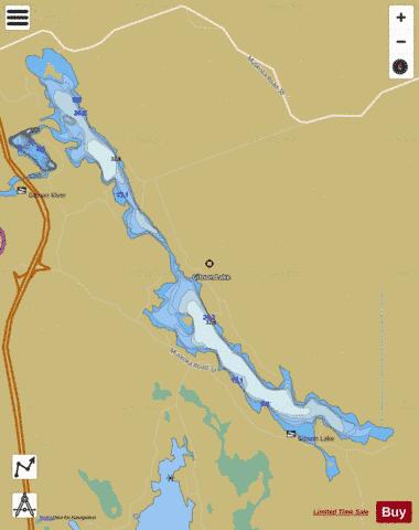
Gibson Lake Fishing Map Stats | |
| Title | Gibson Lake |
| Scale | 1:12000 |
| Districts | Muskoka |
| Nearby Cities | Tay, Midland, Gravenhurst, Elmvale, Marchmont - Bass Lake, Bracebridge, Amigo Beach, Parry Sound, Orillia, Wasaga Beach |
| Area * | 617.13 acres |
| Shoreline * | 15.90 miles |
| Min Longitude | -79.78 |
| Min Latitude | 44.94 |
| Max Longitude | -79.71 |
| Max Latitude | 44.99 |
| Edition Label 1 | |
| Edition Label 2 | |
| Edition Label 3 | |
| Id | CA_ON_V_103381828 |
| Country | CA |
| Projection | Mercator |
| * some Stats may include nearby/connecting waterbodies | |
|