Panache Lake fishing map is included in Ontario Lakes nautical charts folio. It is available as part of iBoating : Canada Marine & Fishing App (now supported on multiple platforms including Android, iPhone/iPad, MacBook, and Windows(tablet and phone)/PC based chartplotter. ).
With our Lake Maps App, you get all the great marine chart app features like fishing spots, along with Panache Lake depth map. The fishing maps app include HD lake depth contours, along with advanced features found in Fish Finder / Gps Chart Plotter systems, turning your device into a Depth Finder. The Panache Lake Navigation App provides advanced features of a Marine Chartplotter including adjusting water level offset and custom depth shading. Fishing spots and depth contours layers are available in most Lake maps. Lake navigation features include advanced instrumentation to gather wind speed direction, water temperature, water depth, and accurate GPS with AIS receivers(using NMEA over TCP/UDP). Autopilot support can be enabled during ‘Goto WayPoint’ and ‘Route Assistance’.
Now i-Boating supports Fishing Points in Panache Lake.
Have more questions about the Nautical Chart App? Ask us.
Fishing Info for Panache Lake
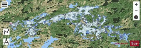
Lake Panache is a lake in the Canadian province of Ontario. It is located in the Sudbury District, although a small portion of the lake lies within the southernmost city limits of Greater Sudbury, approximately 10 kilometres south of the community of Whitefish. The lake's westernmost point lies within Foster township near Espanola, and its easternmost point lies within Bevin township south of Lively. Its main water inflow and outflow is the Whitefish River system. Part of the lake's southern shore forms the boundary of Killarney Lakelands and Headwaters Provincial Park, an extension of Killarney Provincial Park which was designated in 2006. The lake was originally named Panache, in the Canadian French sense of antlers, for its resemblance to a moose antler. It is not known exactly when the lake was so named, although the name appears on maps of the area dating as far back as 1863. Over time, however, the common English spelling of the name morphed into Penage. More recently, official usage has reverted to the original Panache spelling, although Penage is still sometimes seen in everyday usage. A popular recreational cottage lake in the region, the lake is accessible by two roads, Municipal Road 10 (Panache Lake Road) in Greater Sudbury and Penage Lake Road in Espanola. Much of the lake, however, is accessible only via boat from marinas at the ends of the two access roads. The eastern portion of the lake was served by two full service marinas. Gemmell's and Whitehead's are competing marinas providing car and boat parking, fuel, groceries, bait and water taxi service. Gemmell's changed hands in the fall of 1966 and was purchased by the Lundgren and Sutinen families and was renamed Penage Marina. Whitehead's marina was purchased by Bill Blanchard and then resold to Vic and Judy Erola. In the late-1970s, Delky and Louis Dozzi purchased the Erola interests and renamed the marina Penage Bay Marina. In the early-1970s, the Lundgren's sold out to the Sutinen family. In June 1980 the Dozzi brothers purchased the Penage Marina from the Sutinens and combined the two marinas. After 30 years of ownership, Louis Dozzi sold the Penage Bay Marina in 2007 to Guy Richard. In 2021 Guy sold the marina to Brendan and Alex and was rebranded to Panache Bay Marina. The Panache Campers Association has been in the forefront in providing a safe environment for all on the lake. The Association funds and maintains the hazard beacons on the lake as well as being the stewards for a safe and clean environment for all.
More on Wikipedia...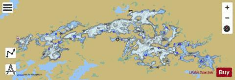
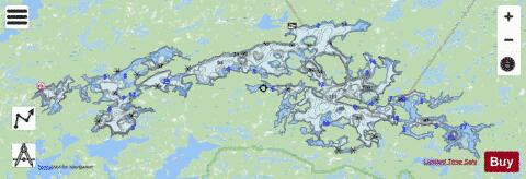
Panache Lake Fishing Map Stats | |
| Title | Panache Lake |
| Scale | 1:24000 |
| Districts | Greater Sudbury / Grand Sudbury, Sudbury |
| Nearby Cities | Espanola, Lively, Chelmsford, Dowling, Azilda, Sudbury, Coniston, Little Current, Valley East, Wikwemikong |
| Area * | 19858.27 acres |
| Shoreline * | 260.80 miles |
| Min Longitude | -81.59 |
| Min Latitude | 46.19 |
| Max Longitude | -81.15 |
| Max Latitude | 46.28 |
| Edition Label 1 | |
| Edition Label 2 | |
| Edition Label 3 | |
| Id | CA_ON_V_103385781 |
| Country | CA |
| Projection | Mercator |
| * some Stats may include nearby/connecting waterbodies | |
|