Montreal Lake fishing map is included in Saskatchewan Fishing Maps nautical charts folio. It is available as part of iBoating : Canada Marine & Fishing App (now supported on multiple platforms including Android, iPhone/iPad, MacBook, and Windows(tablet and phone)/PC based chartplotter. ).
With our Lake Maps App, you get all the great marine chart app features like fishing spots, along with Montreal Lake depth map. The fishing maps app include HD lake depth contours, along with advanced features found in Fish Finder / Gps Chart Plotter systems, turning your device into a Depth Finder. The Montreal Lake Navigation App provides advanced features of a Marine Chartplotter including adjusting water level offset and custom depth shading. Fishing spots and depth contours layers are available in most Lake maps. Lake navigation features include advanced instrumentation to gather wind speed direction, water temperature, water depth, and accurate GPS with AIS receivers(using NMEA over TCP/UDP). Autopilot support can be enabled during ‘Goto WayPoint’ and ‘Route Assistance’.
Have more questions about the Nautical Chart App? Ask us.
Fishing Info for Montreal Lake
Montreal Lake is a lake in the north-central part of Canadian province of Saskatchewan. It is the source of the Montreal River and is located between Highways 2 and 969. Prince Albert National Park is to the west and Clarence-Steepbank Lakes Provincial Park is to the east. Communities on the lake include Montreal Lake, Timber Bay, and Molanosa.
More on Wikipedia...Popular fish species in this lake include Burbot, Cisco (fish), Lake trout, Lake whitefish, Longnose sucker, Northern pike, Walleye, White sucker and Yellow perch.
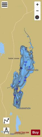
Montreal Lake Fishing Map Stats | |
| Title | Montreal Lake |
| Scale | 1:48000 |
| Nearby Cities | La Ronge, Prince Albert |
| Area * | 114269.24 acres |
| Shoreline * | 177.71 miles |
| Min Longitude | -105.90 |
| Min Latitude | 54.05 |
| Max Longitude | -105.54 |
| Max Latitude | 54.64 |
| Edition Label 1 | |
| Edition Label 2 | |
| Edition Label 3 | |
| Id | CA_SK_Montreal_Lake_sk |
| Country | CA |
| Projection | Mercator |
| * some Stats may include nearby/connecting waterbodies | |
|