Pigeon Lake fishing map is included in Alberta Lakes nautical charts folio. It is available as part of iBoating : Canada Marine & Fishing App (now supported on multiple platforms including Android, iPhone/iPad, MacBook, and Windows(tablet and phone)/PC based chartplotter. ).
With our Lake Maps App, you get all the great marine chart app features like fishing spots, along with Pigeon Lake depth map. The fishing maps app include HD lake depth contours, along with advanced features found in Fish Finder / Gps Chart Plotter systems, turning your device into a Depth Finder. The Pigeon Lake Navigation App provides advanced features of a Marine Chartplotter including adjusting water level offset and custom depth shading. Fishing spots and depth contours layers are available in most Lake maps. Lake navigation features include advanced instrumentation to gather wind speed direction, water temperature, water depth, and accurate GPS with AIS receivers(using NMEA over TCP/UDP). Autopilot support can be enabled during ‘Goto WayPoint’ and ‘Route Assistance’.
Now i-Boating supports Fishing Points in Pigeon Lake.
Have more questions about the Nautical Chart App? Ask us.
Fishing Info for Pigeon Lake
Pigeon Lake is a lake in central Alberta, Canada that straddles the boundary between Leduc County and the County of Wetaskiwin No. 10. It is located close to Edmonton, Leduc and Wetaskiwin. Communities located along the lakeshore include Pigeon Lake Indian Reserve 138A, ten summer villages (Argentia Beach, Crystal Springs, Golden Days, Grandview, Itaska Beach, Ma-Me-O Beach, Norris Beach, Poplar Bay, Silver Beach and Sundance Beach), and four unincorporated communities (Fisher Home, Mission Beach, Mulhurst Bay and Village at Pigeon Lake). The lake has a total area of 96.7 km2 (37.3 sq mi) and a maximum depth of 9.1 m (30 ft). It has a catchment area of 187 km2 (72 sq mi), and is an early tributary of the Battle River, to which it is connected through the Pigeon Lake Creek. Pigeon Lake was previously called "Woodpecker Lake". The name was changed to Pigeon Lake in 1858. In 1896, Pigeon Lake Indian Reserve was established on the southeast shore. Later, the summer village of Ma-Me-O Beach was developed at the south end of the lake on land obtained from the Indian reserve in 1924. Ma-Me-O (omîmîw) is a Cree word meaning "pigeon".
More on Wikipedia...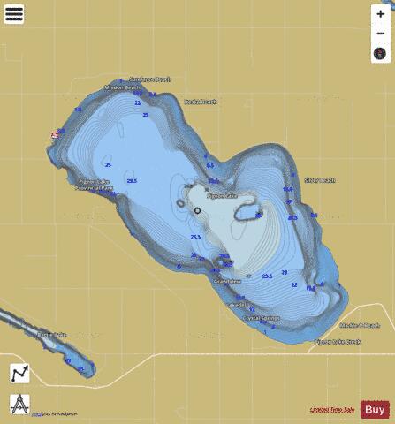
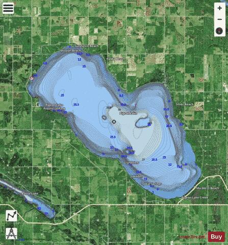
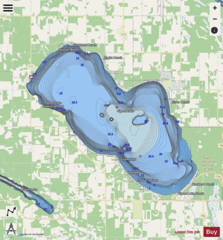
Pigeon Lake Fishing Map Stats | |
| Title | Pigeon Lake |
| Scale | 1:12000 |
| Districts | Division No. 11 |
| Nearby Cities | Calmar, Rimbey, Devon, Stony Plain, Ponoka, Millet, Leduc, Bentley, Spruce Grove, Lacombe |
| Area * | 24084.11 acres |
| Shoreline * | 28.75 miles |
| Min Longitude | -114.18 |
| Min Latitude | 52.96 |
| Max Longitude | -113.95 |
| Max Latitude | 53.08 |
| Edition Label 1 | |
| Edition Label 2 | |
| Edition Label 3 | |
| Id | CA_AB_pigeon_lake |
| Country | CA |
| Projection | Mercator |
| * some Stats may include nearby/connecting waterbodies | |
|