Gun Lake fishing map is included in Lakes and Rivers of British Columbia nautical charts folio. It is available as part of iBoating : Canada Marine & Fishing App (now supported on multiple platforms including Android, iPhone/iPad, MacBook, and Windows(tablet and phone)/PC based chartplotter. ).
With our Lake Maps App, you get all the great marine chart app features like fishing spots, along with Gun Lake depth map. The fishing maps app include HD lake depth contours, along with advanced features found in Fish Finder / Gps Chart Plotter systems, turning your device into a Depth Finder. The Gun Lake Navigation App provides advanced features of a Marine Chartplotter including adjusting water level offset and custom depth shading. Fishing spots and depth contours layers are available in most Lake maps. Lake navigation features include advanced instrumentation to gather wind speed direction, water temperature, water depth, and accurate GPS with AIS receivers(using NMEA over TCP/UDP). Autopilot support can be enabled during ‘Goto WayPoint’ and ‘Route Assistance’.
Now i-Boating supports Fishing Points in Gun Lake.
Have more questions about the Nautical Chart App? Ask us.
Fishing Info for Gun Lake
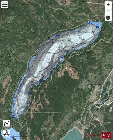
Gun Lake, often spelled Gunn Lake and also known as Big Gun Lake, is a lake and unincorporated community in the Bridge River Country of the West-Central Interior of British Columbia, Canada, located 5 miles northwest of the community of Gold Bridge. It is approximately 6 km in length and is roughly pistol-shaped when seen from above, and drains via a short connecting creek to Gun Creek, which is an important tributary of the Bridge River, joining it via Carpenter Lake. Lajoie Lake, which is just southwest, is also known as Little Gun Lake and is also a small community. The two together are generally referred to as the Gun Lakes. "Big Gun" has a summer population around 100 and has a full-time population of approx 20 people and constitutes one of the main communities of the Bridge River Valley, the others being Gold Bridge and the mining ghost town of Bralorne, and a smaller recreational community in the area of Tyaughton Lake and Gun Creek Road, which runs west from that lake on the north flank of Gun Creek. According to a newspaper article from 1941 written by an early prospector and currently posted in an old mining cabin in Bralorne, Gun Lake and Gun Creek were named because a prospector once lost his Gun in Gun Creek.
More on Wikipedia...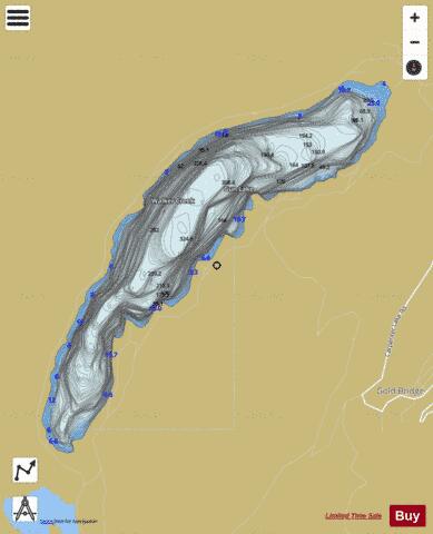
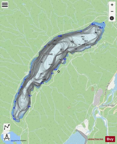
Gun Lake Fishing Map Stats | |
| Title | Gun Lake |
| Scale | 1:12000 |
| Districts | Squamish-Lillooet |
| Nearby Cities | Pemberton, Whistler, Lillooet |
| Area * | 1428.64 acres |
| Shoreline * | 9.79 miles |
| Min Longitude | -122.91 |
| Min Latitude | 50.84 |
| Max Longitude | -122.84 |
| Max Latitude | 50.89 |
| Edition Label 1 | |
| Edition Label 2 | |
| Edition Label 3 | |
| Id | CA_BC_gun_lake_5183 |
| Country | CA |
| Projection | Mercator |
| * some Stats may include nearby/connecting waterbodies | |
| |||||||||||||||||||||||||||||||||||||||||||||||||||||||||||||||||||||||||||||||||||||||||||||||||||||||
|