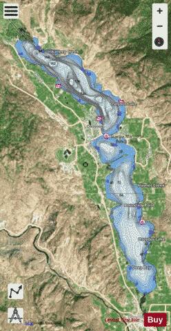
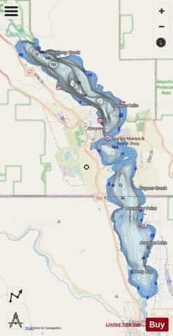
Osoyoos Lake fishing map is included in Lakes and Rivers of British Columbia nautical charts folio. It is available as part of iBoating : Canada Marine & Fishing App (now supported on multiple platforms including Android, iPhone/iPad, MacBook, and Windows(tablet and phone)/PC based chartplotter. ).
With our Lake Maps App, you get all the great marine chart app features like fishing spots, along with Osoyoos Lake depth map. The fishing maps app include HD lake depth contours, along with advanced features found in Fish Finder / Gps Chart Plotter systems, turning your device into a Depth Finder. The Osoyoos Lake Navigation App provides advanced features of a Marine Chartplotter including adjusting water level offset and custom depth shading. Fishing spots and depth contours layers are available in most Lake maps. Lake navigation features include advanced instrumentation to gather wind speed direction, water temperature, water depth, and accurate GPS with AIS receivers(using NMEA over TCP/UDP). Autopilot support can be enabled during ‘Goto WayPoint’ and ‘Route Assistance’.
Now i-Boating supports Fishing Points in Osoyoos Lake.
Have more questions about the Nautical Chart App? Ask us.
Fishing Info for Osoyoos Lake
Osoyoos Lake is a lake located in British Columbia, Canada, and Washington state of the United States. Osoyoos is derived from the word sẁiẁs meaning "narrowing of the waters" in the local Okanagan language (Syilx'tsn). Located on the lakeshore are the town of Osoyoos, British Columbia and city of Oroville, Washington. The lake's maximum elevation is 912.78 ft (278.22 m), while its minimum elevation is 909.46 ft (277.20 m). The 62-year average discharge into the Okanogan River at Oroville is 683 cu ft/s (19.3 m3/s). Maximum discharge in 2004 was 1,340 cu ft/s (38 m3/s). Oroville's Osoyoos Lake State Park is located on its shore.
More on Wikipedia...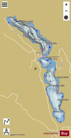
Osoyoos Lake Fishing Map Stats | |
| Title | Osoyoos Lake |
| Scale | 1:24000 |
| Districts | Okanagan-Similkameen |
| Nearby Cities | Osoyoos, Oliver, Okanagan Falls, Keremeos, Penticton, Naramata, Summerland, Peachland, Kelowna, Duck Lake |
| Area * | 5765.69 acres |
| Shoreline * | 32.86 miles |
| Min Longitude | -119.53 |
| Min Latitude | 48.95 |
| Max Longitude | -119.42 |
| Max Latitude | 49.08 |
| Edition Label 1 | |
| Edition Label 2 | |
| Edition Label 3 | |
| Id | CA_BC_osoyoos_lake__bc |
| Country | CA |
| Projection | Mercator |
| * some Stats may include nearby/connecting waterbodies | |
|