Somenos Lake fishing map is included in Lakes and Rivers of British Columbia nautical charts folio. It is available as part of iBoating : Canada Marine & Fishing App (now supported on multiple platforms including Android, iPhone/iPad, MacBook, and Windows(tablet and phone)/PC based chartplotter. ).
With our Lake Maps App, you get all the great marine chart app features like fishing spots, along with Somenos Lake depth map. The fishing maps app include HD lake depth contours, along with advanced features found in Fish Finder / Gps Chart Plotter systems, turning your device into a Depth Finder. The Somenos Lake Navigation App provides advanced features of a Marine Chartplotter including adjusting water level offset and custom depth shading. Fishing spots and depth contours layers are available in most Lake maps. Lake navigation features include advanced instrumentation to gather wind speed direction, water temperature, water depth, and accurate GPS with AIS receivers(using NMEA over TCP/UDP). Autopilot support can be enabled during ‘Goto WayPoint’ and ‘Route Assistance’.
Now i-Boating supports Fishing Points in Somenos Lake.
Have more questions about the Nautical Chart App? Ask us.
Fishing Info for Somenos Lake
Somenos Lake is a small shallow water body located in the Municipality of North Cowichan on Southeast Vancouver Island. Somenos Lake has a maximum area of approximately 247 ac, 100 ha at 15.3 feet (4.7 m) above geodetic datum. The Lake is relatively shallow with a maximum depth of 22.2 feet (6.8 m). Somenos Lake is fed by three major tributary streams: Richards Creek from the North and Northeast, Averill Creek from the Northwest and Bings Creek from the West. The lake is drained near its southern extremity by Somenos Creek which flows southeast approximately 4 kilometres (2.5 mi) to the Cowichan River. Somenos Lake and its tributary streams support resident populations of Rainbow Trout (Oncorhynchus mykiss) and Cutthroat Trout (O. clarkii). Anadromous populations of Coho Salmon (O. kisutch) and Chum Salmon (O. keta) spawn in the tributary streams. The Lake also contains populations of native Brown Bullhead (Ameiurus nebulosus), Three-Spined Stickleback (Gasterosteus aculeatus), and Peamouth Chub (Mylocheilus caurinus). The Invasive species Pumpkinseed (Lepomis gibbosus) has been in the lake since the 1970s. and is now the most abundant fish species. In addition to these fish species, Somenos Lake and associated marsh habitats are an important winter refuge for numerous species of ducks, geese and swans. Of particular interest to conservation is the large number of Trumpeter Swans (Cygnus buccinator) that arrive at Somenos Lake in October and remain until early April. During the past two decades Somenos Lake has been subject to persistent cyanobacteria blooms during the summers. These blooms render the lake unsuitable for human uses like swimming, canoeing and birding. The decay of the highly productive cyanobacteria also generates anoxic conditions in the water column which severely limits habitat for trout and salmon. These blooms are the result of excessive phosphorus in the lake due to deforestation and excessive use of phosphate fertilizers in surrounding agricultural and urban lands.
More on Wikipedia...Popular fish species in this lake include Brown bullhead, Chum salmon, Mylocheilus caurinus, Pumpkinseed, Rainbow trout and Three-spined stickleback.
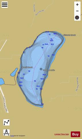
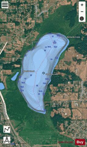
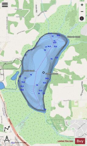
Somenos Lake Fishing Map Stats | |
| Title | Somenos Lake |
| Scale | 1:12000 |
| Districts | Cowichan Valley |
| Nearby Cities | Duncan, Crofton, Cowichan Bay, Chemainus, Shawnigan - Mill Bay, Cobble Hill, Ladysmith, Cedar, Lake Cowichan, Victoria |
| Area * | 239.24 acres |
| Shoreline * | 2.76 miles |
| Min Longitude | -123.71 |
| Min Latitude | 48.79 |
| Max Longitude | -123.70 |
| Max Latitude | 48.81 |
| Edition Label 1 | |
| Edition Label 2 | |
| Edition Label 3 | |
| Id | CA_BC_somenos_lake__bc |
| Country | CA |
| Projection | Mercator |
| * some Stats may include nearby/connecting waterbodies | |
| ||||||||||||||||||||||||||||||||||||||||||||||||||||||||||||||||||||||||||||||||||||||||||||||||||||||||
|