Taseko Lakes fishing map is included in Lakes and Rivers of British Columbia nautical charts folio. It is available as part of iBoating : Canada Marine & Fishing App (now supported on multiple platforms including Android, iPhone/iPad, MacBook, and Windows(tablet and phone)/PC based chartplotter. ).
With our Lake Maps App, you get all the great marine chart app features like fishing spots, along with Taseko Lakes lake depth map. The fishing maps app include HD lake depth contours, along with advanced features found in Fish Finder / Gps Chart Plotter systems, turning your device into a Depth Finder. The Taseko Lakes Navigation App provides advanced features of a Marine Chartplotter including adjusting water level offset and custom depth shading. Fishing spots and depth contours layers are available in most Lake maps. Lake navigation features include advanced instrumentation to gather wind speed direction, water temperature, water depth, and accurate GPS with AIS receivers(using NMEA over TCP/UDP). Autopilot support can be enabled during ‘Goto WayPoint’ and ‘Route Assistance’.
Now i-Boating supports Fishing Points in Taseko Lakes.
Have more questions about the Nautical Chart App? Ask us.
Fishing Info for Taseko Lakes
The Taseko Lakes are a pair of lakes, Upper Taseko Lake and Lower Taseko Lake, which are expansions of the upper Taseko River in the southern Chilcotin District of the Central Interior of British Columbia, Canada. Their name is based on the original in the Chilcotin language, Dasiqox Biny, where "Desiqox" means "Mosquito River" and is cognate to the name of the river as in English; the Chilcotin name refers to both lakes as one lake, which was also originally the case with the English usage until official designation of the separate lakes in 1954. The lakes are separated by the short Taseko Narrows, the name of which in Chilcotin is nanats'akash, and is an important crossing place for deer. The Tchaikazan River flows the area between the upper & lower lake from the southwest, while the Taseko River feeds it from the southeast, while the equally large Lord River joins it from the south, at the head of the lake.
More on Wikipedia...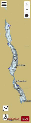
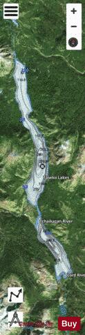
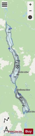
Taseko Lakes Fishing Map Stats | |
| Title | Taseko Lakes |
| Scale | 1:24000 |
| Districts | Cariboo |
| Area * | 7731.54 acres |
| Shoreline * | 39.36 miles |
| Min Longitude | -123.63 |
| Min Latitude | 51.15 |
| Max Longitude | -123.54 |
| Max Latitude | 51.37 |
| Edition Label 1 | |
| Edition Label 2 | |
| Edition Label 3 | |
| Id | CA_BC_taseko_lakes_bc |
| Country | CA |
| Projection | Mercator |
| * some Stats may include nearby/connecting waterbodies | |
| |||||||||||||||||||||||||||||||||||||||||||||||||||||||||||||||||||||||||||||||||||||||||||||||||||||||
|