Stendorfer See fishing map is included in Germany - Schleswig-Holstein Lakes nautical charts folio. It is available as part of iBoating : Inland Europe Marine & Fishing App (now supported on multiple platforms including Android, iPhone/iPad, MacBook, and Windows(tablet and phone)/PC based chartplotter. ).
With our Lake Maps App, you get all the great marine chart app features like fishing spots, along with Stendorfer See lake depth map. The fishing maps app include HD lake depth contours, along with advanced features found in Fish Finder / Gps Chart Plotter systems, turning your device into a Depth Finder. The Stendorfer See Navigation App provides advanced features of a Marine Chartplotter including adjusting water level offset and custom depth shading. Fishing spots and depth contours layers are available in most Lake maps. Lake navigation features include advanced instrumentation to gather wind speed direction, water temperature, water depth, and accurate GPS with AIS receivers(using NMEA over TCP/UDP). Autopilot support can be enabled during ‘Goto WayPoint’ and ‘Route Assistance’.
Have more questions about the Nautical Chart App? Ask us.
Fishing Info for Stendorfer See
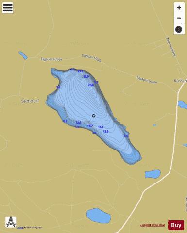
The Stendorfer See is a lake west of Kasseedorf in Holstein Switzerland, Schleswig-Holstein, Germany. The lake lies east of the Stendorf Manor House in the parish of Kasseedorf and is surrounded by a rolling moraine landscape. The lake is oblong in shape with a maximum length of about 1,500 metres and a maximum width of about 700 metres. It has an area of some 54 hectares (130 acres) and a maximum depth of about 8 metres, the deepest point being near its northeastern shore. It lies at an elevation of around 32.6 m above sea level (NN). The Stendorfer See is crossed by the River Schwentine from east to west. In addition several smaller lakes and ponds drain into it - including the to the southwest and the Oberteich. It is used as a fishing lake. In addition to pike, eel, perch, tench and stocked carp, burbot may also be caught occasionally.
More on Wikipedia...Popular fish species in this lake include Burbot, Common carp, European eel and Northern pike.
Stendorfer See Fishing Map Stats | |
| Title | Stendorfer See |
| Scale | 1:6000 |
| Area * | 129.23 acres |
| Shoreline * | 2.29 miles |
| Min Longitude | 10.70 |
| Min Latitude | 54.16 |
| Max Longitude | 10.71 |
| Max Latitude | 54.17 |
| Edition Label 1 | |
| Edition Label 2 | |
| Edition Label 3 | |
| Id | II_DE_stendorfer_see_de |
| Country | Inland Europe |
| Projection | Mercator |
| * some Stats may include nearby/connecting waterbodies | |
|