Buttermere + Crummock Water fishing map is included in England - Cumbria Lakes nautical charts folio. It is available as part of iBoating : Inland Europe Marine & Fishing App (now supported on multiple platforms including Android, iPhone/iPad, MacBook, and Windows(tablet and phone)/PC based chartplotter. ).
With our Lake Maps App, you get all the great marine chart app features like fishing spots, along with Buttermere + Crummock Water lake depth map. The fishing maps app include HD lake depth contours, along with advanced features found in Fish Finder / Gps Chart Plotter systems, turning your device into a Depth Finder. The Buttermere + Crummock Water Navigation App provides advanced features of a Marine Chartplotter including adjusting water level offset and custom depth shading. Fishing spots and depth contours layers are available in most Lake maps. Lake navigation features include advanced instrumentation to gather wind speed direction, water temperature, water depth, and accurate GPS with AIS receivers(using NMEA over TCP/UDP). Autopilot support can be enabled during ‘Goto WayPoint’ and ‘Route Assistance’.
Have more questions about the Nautical Chart App? Ask us.
Fishing Info for Buttermere + Crummock Water
Crummock Water is a lake in the Lake District in Cumbria, North West England situated between Buttermere to the south and Loweswater to the north. Crummock Water is 2.5 miles (4.0 km) long, 0.6 miles (0.97 km) wide and 140 feet (43 m) deep. The River Cocker is considered to start at the north of the lake, before then flowing into Lorton Vale. The hill of Mellbreak runs the full length of the lake on its western side; as Alfred Wainwright described it 'no pairing of hill and lake in Lakeland have a closer partnership than these'. The lake is owned by the National Trust. "The meaning of 'Crummock' seems to be 'Crooked one', from British" (Brythonic Celtic) "'crumbaco'-'crooked'". This may refer to the winding course of the River Cocker, which flows out of the lake, or refer to the bending nature of the lake itself. The word "'water' is the main Lakeland term for 'lake'". Scale Force, the highest waterfall in the Lake District, feeds the lake and has a drop of 170 feet (52 m). Water from the lake is treated at Cornhow water treatment works, near Loweswater, and is distributed to the towns of Silloth-on-Solway, Maryport, Workington, Whitehaven, and many smaller towns, villages, and hamlets in the surrounding area for drinking and all other uses. Crummock Water gained attention in 1988 when the body of Sheena Owlett was found in the lake. It later transpired she had been murdered in Wetherby, West Yorkshire.
More on Wikipedia...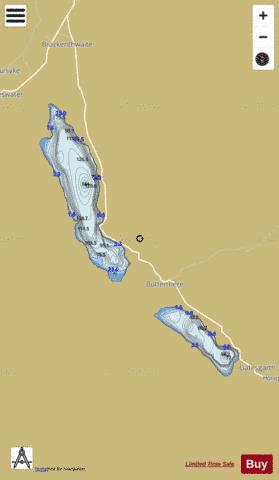
Buttermere + Crummock Water Fishing Map Stats | |
| Title | Buttermere + Crummock Water |
| Scale | 1:12000 |
| Area * | 841.99 acres |
| Shoreline * | 9.28 miles |
| Min Longitude | -3.32 |
| Min Latitude | 54.52 |
| Max Longitude | -3.25 |
| Max Latitude | 54.58 |
| Edition Label 1 | |
| Edition Label 2 | |
| Edition Label 3 | |
| Id | II_GB_crummock_water__gb |
| Country | Inland Europe |
| Projection | Mercator |
| * some Stats may include nearby/connecting waterbodies | |
| ||||||||||||||||||||||||||||||||||||||||||||||||||||||||||||||||||||||||||||||||||||||||||||||||||||||||
|