Esthwaite Water fishing map is included in England - Cumbria Lakes nautical charts folio. It is available as part of iBoating : Inland Europe Marine & Fishing App (now supported on multiple platforms including Android, iPhone/iPad, MacBook, and Windows(tablet and phone)/PC based chartplotter. ).
With our Lake Maps App, you get all the great marine chart app features like fishing spots, along with Esthwaite Water lake depth map. The fishing maps app include HD lake depth contours, along with advanced features found in Fish Finder / Gps Chart Plotter systems, turning your device into a Depth Finder. The Esthwaite Water Navigation App provides advanced features of a Marine Chartplotter including adjusting water level offset and custom depth shading. Fishing spots and depth contours layers are available in most Lake maps. Lake navigation features include advanced instrumentation to gather wind speed direction, water temperature, water depth, and accurate GPS with AIS receivers(using NMEA over TCP/UDP). Autopilot support can be enabled during ‘Goto WayPoint’ and ‘Route Assistance’.
Have more questions about the Nautical Chart App? Ask us.
Fishing Info for Esthwaite Water
Esthwaite Water is one of the smaller and lesser known lakes in the Lake District National Park in northern England. It is situated between the much larger lakes of Windermere and Coniston Water, in the traditional county of Lancashire; since 1974 in the county of Cumbria. To the north is the village of Hawkshead and to the west is Grizedale Forest. The lake covers around 280 acres (1.1 km2) and is known for its excellent fishing, particularly trout and pike. It has been designated as a site of special scientific interest.
More on Wikipedia...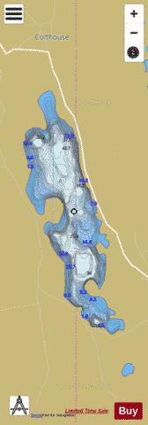
Esthwaite Water Fishing Map Stats | |
| Title | Esthwaite Water |
| Scale | 1:12000 |
| Area * | 237.85 acres |
| Shoreline * | 4.74 miles |
| Min Longitude | -2.99 |
| Min Latitude | 54.35 |
| Max Longitude | -2.98 |
| Max Latitude | 54.37 |
| Edition Label 1 | |
| Edition Label 2 | |
| Edition Label 3 | |
| Id | II_GB_esthwaite_water__gb |
| Country | Inland Europe |
| Projection | Mercator |
| * some Stats may include nearby/connecting waterbodies | |
| |||||||||||||||||||||||||||||||||||||||||||||||||||||||||||||||||||||||||||||||||||||||||||||||||||||||
|