Byglandsfjorden fishing map is included in √ėstfold nautical charts folio. It is available as part of iBoating : Norway Marine & Fishing App (now supported on multiple platforms including Android, iPhone/iPad, MacBook, and Windows(tablet and phone)/PC based chartplotter. ).
With our Lake Maps App, you get all the great marine chart app features like fishing spots, along with Byglandsfjorden lake depth map. The fishing maps app include HD lake depth contours, along with advanced features found in Fish Finder / Gps Chart Plotter systems, turning your device into a Depth Finder. The Byglandsfjorden Navigation App provides advanced features of a Marine Chartplotter including adjusting water level offset and custom depth shading. Fishing spots and depth contours layers are available in most Lake maps. Lake navigation features include advanced instrumentation to gather wind speed direction, water temperature, water depth, and accurate GPS with AIS receivers(using NMEA over TCP/UDP). Autopilot support can be enabled during ‚ÄėGoto WayPoint‚Äô and ‚ÄėRoute Assistance‚Äô.
Have more questions about the Nautical Chart App? Ask us.
Fishing Info for Byglandsfjorden
Byglandsfjorden is a lake in Agder county, Norway. The 32.79-square-kilometre (12.66 sq mi) lake lies on the river Otra, primarily in the municipality of Bygland, but the far southern tip of the lake extends into the neighboring municipality of Evje og Hornnes. The river flows out of the lake √Öraksfjorden to the north and into the Byglandsfjorden through a narrow channel, and the southern end of the Byglandsfjorden is marked by a dam along the river. The villages of Byglandsfjord, Grendi, Longerak, Lauvdal, and Bygland are all located on the eastern shore of the lake along the Norwegian National Road 9. The western shore of the lake is much more sparsely populated, with County Road 304 following that shoreline. The SS Bjoren is a wood-fueled steamboat that travels on the Byglandsfjorden in the summers between the villages of Ose (on the √Öraksfjorden), Bygland, and Byglandsfjord. Prior to the opening of the roads along the shoreline, steamboat travel was the main method of transportation for those travelling north through Setesdal. There is a special relict species of salmon that live in Byglandsfjorden, called bleke. This species of salmon only occurs right there. These are salmon which are not wandering, they spend their entire lives in freshwater.
More on Wikipedia...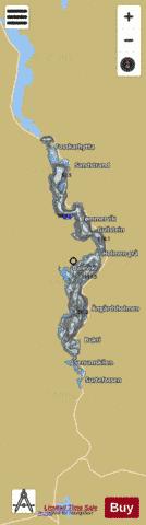
Byglandsfjorden Fishing Map Stats | |
| Title | Byglandsfjorden |
| Scale | 1:24000 |
| Min Longitude | 7.75 |
| Min Latitude | 58.65 |
| Max Longitude | 7.85 |
| Max Latitude | 58.85 |
| Edition Label 1 | |
| Edition Label 2 | |
| Edition Label 3 | |
| Id | NO_LK_1063 |
| Country | Norway |
| Projection | Mercator |
| * some Stats may include nearby/connecting waterbodies | |
|