LAKE TARPON fishing map is available as part of iBoating : USA Marine & Fishing App(now supported on multiple platforms including Android, iPhone/iPad, MacBook, and Windows(tablet and phone)/PC based chartplotter.).
With our Lake Maps App, you get all the great marine chart app features like fishing spots, along with LAKE TARPON depth map. The fishing maps app include HD lake depth contours, along with advanced features found in Fish Finder / Gps Chart Plotter systems, turning your device into a Depth Finder. The LAKE TARPON Navigation App provides advanced features of a Marine Chartplotter including adjusting water level offset and custom depth shading. Fishing spots and depth contours layers are available in most Lake maps. Lake navigation features include advanced instrumentation to gather wind speed direction, water temperature, water depth, and accurate GPS with AIS receivers(using NMEA over TCP/UDP). Autopilot support can be enabled during ‘Goto WayPoint’ and ‘Route Assistance’.
Now i-Boating supports Fishing Points in LAKE TARPON.
Have more questions about the Nautical Chart App? Ask us.
Fishing Info for LAKE TARPON
Lake Tarpon is a freshwater lake located about 10 miles (16 km) west of Tampa in Palm Harbor and Tarpon Springs, Florida. Lake Tarpon is the largest freshwater lake in Pinellas County with a surface area of 2,534 acres (10.25 km2).Its watershed encompasses 52 square miles (130 km2). Its two largest tributaries are South Creek and Brooker Creek.The lake is a regional recreational destination and is renowned for its largemouth bass fishing. Although Lake Tarpon is designated as a fishing lake, it fails to meet the EPA's standards, and is therefore listed as an impaired lake due to its excessive nutrients and resulting low dissolved oxygen levels. The lake underwent increasing eutrophication during the 1990s, following a large algal bloom in 1987. Although initial studies determined that the lake was not polluted, studies in the following years noted a decline in the lake's water quality.
More on Wikipedia...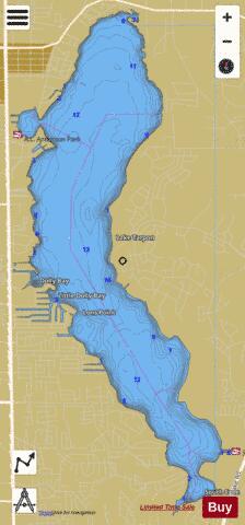
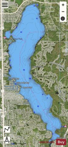

LAKE TARPON Fishing Map Stats | |
| Title | LAKE TARPON |
| Scale | 1:12000 |
| 1 ft Depth Contours for Anglers | Yes |
| Counties | Pinellas |
| Nearby Cities | Tarpon Springs, Palm Harbor, Curlew, Holiday, Crystal Beach, Oldsmar, Elfers, Dunedin, Safety Harbor, New Port Richey |
| Area * | 2528.88 acres |
| Shoreline * | 24.49 miles |
| Min Longitude | -82.74 |
| Min Latitude | 28.08 |
| Max Longitude | -82.70 |
| Max Latitude | 28.15 |
| Edition Label 1 | |
| Edition Label 2 | |
| Edition Label 3 | |
| Id | US_FL_00292049 |
| Country | US |
| Projection | Mercator |
| * some Stats may include nearby/connecting waterbodies | |
|