Grand Sable Lake fishing map is available as part of iBoating : USA Marine & Fishing App(now supported on multiple platforms including Android, iPhone/iPad, MacBook, and Windows(tablet and phone)/PC based chartplotter.).
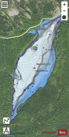
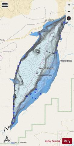
With our Lake Maps App, you get all the great marine chart app features like fishing spots, along with Grand Sable Lake depth map. The fishing maps app include HD lake depth contours, along with advanced features found in Fish Finder / Gps Chart Plotter systems, turning your device into a Depth Finder. The Grand Sable Lake Navigation App provides advanced features of a Marine Chartplotter including adjusting water level offset and custom depth shading. Fishing spots and depth contours layers are available in most Lake maps. Lake navigation features include advanced instrumentation to gather wind speed direction, water temperature, water depth, and accurate GPS with AIS receivers(using NMEA over TCP/UDP). Autopilot support can be enabled during ‘Goto WayPoint’ and ‘Route Assistance’.
Now i-Boating supports Fishing Points in Grand Sable Lake.
Have more questions about the Nautical Chart App? Ask us.
Fishing Info for Grand Sable Lake
Grand Sable Lake is an undeveloped lake in Michigan's Upper Peninsula near the town of Grand Marais, Michigan. It lies within the boundaries of the Pictured Rocks National Lakeshore. County Highway H-58 runs along the northwestern shore of the lake and provides access to the Grand Sable Dunes which overlook the lake. Additionally, there is a sandy beach and picnic area available to visitors. There is a concrete boat access site on the eastern shore of the lake. The soils around Grand Sable Lake are very sandy and the shoreline is mostly wooded
More on Wikipedia...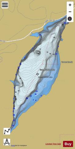
Grand Sable Lake Fishing Map Stats | |
| Title | Grand Sable Lake |
| Scale | 1:12000 |
| Includes Data from Fish Atlas | Yes |
| Counties | Alger |
| Nearby Cities | Grand Marais, Seney, Germfask, Melstrand, McMillan, Shingleton, Steuben, Newberry, Wetmore, Munising |
| Area * | 656.02 acres |
| Shoreline * | 6.19 miles |
| Min Longitude | -86.05 |
| Min Latitude | 46.62 |
| Max Longitude | -86.03 |
| Max Latitude | 46.65 |
| Edition Label 1 | |
| Edition Label 2 | |
| Edition Label 3 | |
| Id | US_MI_2_775 |
| Country | US |
| Projection | Mercator |
| * some Stats may include nearby/connecting waterbodies | |
|