Brevoort Lake fishing map is available as part of iBoating : USA Marine & Fishing App(now supported on multiple platforms including Android, iPhone/iPad, MacBook, and Windows(tablet and phone)/PC based chartplotter.).
With our Lake Maps App, you get all the great marine chart app features like fishing spots, along with Brevoort Lake depth map. The fishing maps app include HD lake depth contours, along with advanced features found in Fish Finder / Gps Chart Plotter systems, turning your device into a Depth Finder. The Brevoort Lake Navigation App provides advanced features of a Marine Chartplotter including adjusting water level offset and custom depth shading. Fishing spots and depth contours layers are available in most Lake maps. Lake navigation features include advanced instrumentation to gather wind speed direction, water temperature, water depth, and accurate GPS with AIS receivers(using NMEA over TCP/UDP). Autopilot support can be enabled during ‘Goto WayPoint’ and ‘Route Assistance’.
Now i-Boating supports Fishing Points in Brevoort Lake.
Have more questions about the Nautical Chart App? Ask us.
Fishing Info for Brevoort Lake
Brevoort Lake is a 4,233-acre (1,713 ha) lake in Mackinac County in the U.S. state of Michigan. Much of the lake's sandy shoreline is owned by the National Forest Service as part of Hiawatha National Forest. In summer months, the National Forest operates Brevoort Lake Campground and the adjacent Brevoort Lake Recreation Area, a beach with boat-launch facilities, on and adjacent to a narrow, sandy peninsula that separates most of the lake from Boedne Bay. A fee is charged for use of the campground. Game fish species occurring in the lake include walleye, northern pike, smallmouth bass, yellow perch, crappies, muskellunge, and sunfish. The lake's surveyed elevation is 623 feet (190 m) above sea level. It drains via the Brevoort River into Lake Michigan.
More on Wikipedia...Popular fish species in this lake include Lake herring.
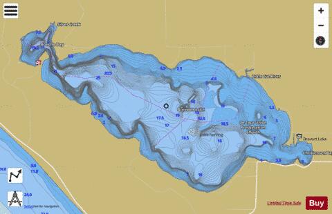
Brevoort Lake Fishing Map Stats | |
| Title | Brevoort Lake |
| Scale | 1:24000 |
| Includes Data from Fish Atlas | Yes |
| Counties | Mackinac |
| Nearby Cities | Moran, Brevort, Trout Lake, Saint Ignace, Mackinaw City, Mackinac Island, Rexton, Carp Lake, Eckerman, Cross Village |
| Area * | 4316.83 acres |
| Shoreline * | 17.76 miles |
| Min Longitude | -84.98 |
| Min Latitude | 45.98 |
| Max Longitude | -84.87 |
| Max Latitude | 46.02 |
| Edition Label 1 | |
| Edition Label 2 | |
| Edition Label 3 | |
| Id | US_MI_49_45 |
| Country | US |
| Projection | Mercator |
| * some Stats may include nearby/connecting waterbodies | |
|