Pine Lake fishing map is available as part of iBoating : USA Marine & Fishing App(now supported on multiple platforms including Android, iPhone/iPad, MacBook, and Windows(tablet and phone)/PC based chartplotter.).
With our Lake Maps App, you get all the great marine chart app features like fishing spots, along with Pine Lake depth map. The fishing maps app include HD lake depth contours, along with advanced features found in Fish Finder / Gps Chart Plotter systems, turning your device into a Depth Finder. The Pine Lake Navigation App provides advanced features of a Marine Chartplotter including adjusting water level offset and custom depth shading. Fishing spots and depth contours layers are available in most Lake maps. Lake navigation features include advanced instrumentation to gather wind speed direction, water temperature, water depth, and accurate GPS with AIS receivers(using NMEA over TCP/UDP). Autopilot support can be enabled during ‘Goto WayPoint’ and ‘Route Assistance’.
Now i-Boating supports Fishing Points in Pine Lake.
Have more questions about the Nautical Chart App? Ask us.
Fishing Info for Pine Lake
Pine Lake is a private, all-sports, 395-acre lake in West Bloomfield Township, Oakland County, in the U.S. state of Michigan. The Pine Lake shoreline is lined with high-end exclusive homes. In addition to Pine Lake Marina, Pine Lake Country Club is also located on the lake. The 90-foot-deep (27 m) lake is the sixth-deepest lake in Oakland County. The ten deepest lakes in Oakland County are: 1. Cass Lake (Waterford Twp. and West Bloomfield Twp.) 123 feet2. Maceday Lake (Waterford Twp.) 117 feet3t. Orchard Lake (West Bloomfield Twp.) 110 feet3t. Union Lake (Commerce Twp.) 110 feet5. Walnut Lake (West Bloomfield Twp.) 101 feet6t. Van Norman Lake (Independence Twp. and Waterford Twp.) 90 feet6t. Pine Lake (West Bloomfield Twp.) 90 feet8. Lake Angelus (Auburn Hills) 88 feet9t. Loon Lake (Waterford Twp.) 73 feet9t. Silver Lake (Waterford Twp.) 73 feet
More on Wikipedia...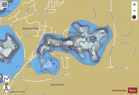
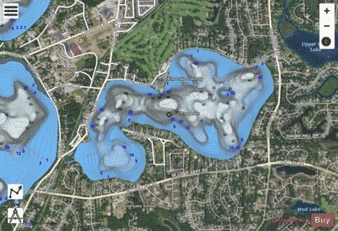
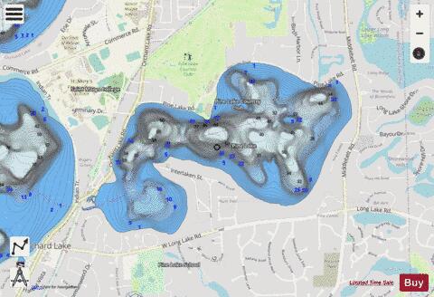
Pine Lake Fishing Map Stats | |
| Title | Pine Lake |
| Scale | 1:12000 |
| Includes Data from Fish Atlas | Yes |
| Counties | Oakland |
| Nearby Cities | Keego Harbor, Sylvan Lake, Orchard Lake Village, Pontiac, Franklin, Westacres, Bloomfield Hills, Bingham Farms, Union Lake, Farmington Hills |
| Area * | 390.64 acres |
| Shoreline * | 4.76 miles |
| Min Longitude | -83.36 |
| Min Latitude | 42.58 |
| Max Longitude | -83.33 |
| Max Latitude | 42.60 |
| Edition Label 1 | |
| Edition Label 2 | |
| Edition Label 3 | |
| Id | US_MI_oakmich_pine_lake |
| Country | US |
| Projection | Mercator |
| * some Stats may include nearby/connecting waterbodies | |
|