Farm Island fishing map is available as part of iBoating : USA Marine & Fishing App(now supported on multiple platforms including Android, iPhone/iPad, MacBook, and Windows(tablet and phone)/PC based chartplotter.).
With our Lake Maps App, you get all the great marine chart app features like fishing spots, along with Farm Island lake depth map. The fishing maps app include HD lake depth contours, along with advanced features found in Fish Finder / Gps Chart Plotter systems, turning your device into a Depth Finder. The Farm Island Navigation App provides advanced features of a Marine Chartplotter including adjusting water level offset and custom depth shading. Fishing spots and depth contours layers are available in most Lake maps. Lake navigation features include advanced instrumentation to gather wind speed direction, water temperature, water depth, and accurate GPS with AIS receivers(using NMEA over TCP/UDP). Autopilot support can be enabled during ‘Goto WayPoint’ and ‘Route Assistance’.
Now i-Boating supports Fishing Points in Farm Island.
Have more questions about the Nautical Chart App? Ask us.
Fishing Info for Farm Island
Farm Island Lake is a lake in the U.S. state of Minnesota, located in Aitkin County north of Mille Lacs Lake. It is just west of U.S. Route 169. Zebra mussels, an invasive species, have been found there. Its name refers to traditional farming of islands in the lake by Ojibwe people. They also hunted, fished, and harvested wild rice. The Minnesota Department of Natural Resources maintains Farm Island State Wildlife Management Area and two public boat launches on the lake.
More on Wikipedia...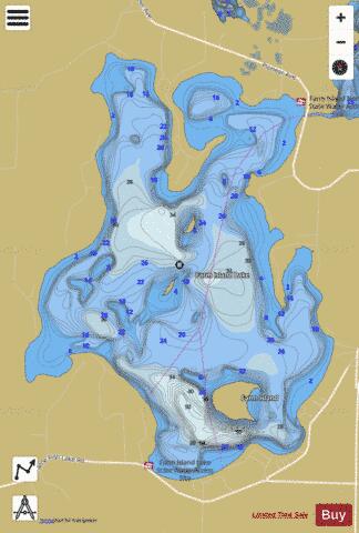
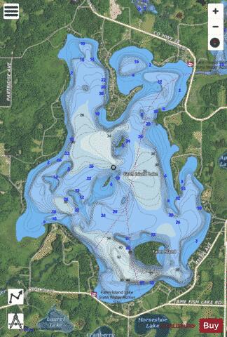
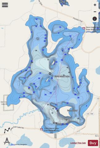
Farm Island Fishing Map Stats | |
| Title | Farm Island |
| Scale | 1:6000 |
| Counties | Aitkin |
| Nearby Cities | Aitkin, Deerwood, Garrison, Cuyuna, Crosby, Ironton, Hassman, Pine Center, Glen, Vineland |
| Area * | 2004.38 acres |
| Shoreline * | 14.72 miles |
| Min Longitude | -93.79 |
| Min Latitude | 46.40 |
| Max Longitude | -93.75 |
| Max Latitude | 46.44 |
| Edition Label 1 | |
| Edition Label 2 | |
| Edition Label 3 | |
| Id | US_MN_01015900 |
| Country | US |
| Projection | Mercator |
| * some Stats may include nearby/connecting waterbodies | |
|