LAKE MONROE fishing map is available as part of iBoating : USA Marine & Fishing App(now supported on multiple platforms including Android, iPhone/iPad, MacBook, and Windows(tablet and phone)/PC based chartplotter.).
With our Lake Maps App, you get all the great marine chart app features like fishing spots, along with LAKE MONROE depth map. The fishing maps app include HD lake depth contours, along with advanced features found in Fish Finder / Gps Chart Plotter systems, turning your device into a Depth Finder. The LAKE MONROE Navigation App provides advanced features of a Marine Chartplotter including adjusting water level offset and custom depth shading. Fishing spots and depth contours layers are available in most Lake maps. Lake navigation features include advanced instrumentation to gather wind speed direction, water temperature, water depth, and accurate GPS with AIS receivers(using NMEA over TCP/UDP). Autopilot support can be enabled during ‘Goto WayPoint’ and ‘Route Assistance’.
Now i-Boating supports Fishing Points in LAKE MONROE.
Have more questions about the Nautical Chart App? Ask us.
Fishing Info for LAKE MONROE
Lake Monroe is one of the lakes that make up the St. Johns River system. The port city of Sanford is situated along the southern shore, while DeBary and Deltona are located along the northern shore. Two major central Florida roadways that run near the lake are State Road 415 and Interstate 4. It forms the border of Seminole County and Volusia County It is the 8th largest lake in the Orlando metropolitan area, after Lake Jesup, 7 miles (11 km) to the south.
More on Wikipedia...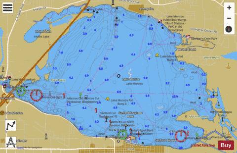
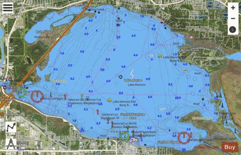
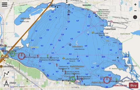
LAKE MONROE Fishing Map Stats | |
| Title | LAKE MONROE |
| Scale | 1:12000 |
| 1 ft Depth Contours for Anglers | Yes |
| Counties | Seminole, Volusia |
| Nearby Cities | Enterprise, Lake Monroe, Sanford, DeBary, Midway, Deltona, Osteen, Lake Mary, Orange City, Heathrow |
| Area * | 9285.96 acres |
| Shoreline * | 39.76 miles |
| Min Longitude | -81.32 |
| Min Latitude | 28.81 |
| Max Longitude | -81.22 |
| Max Latitude | 28.87 |
| Edition Label 1 | |
| Edition Label 2 | |
| Edition Label 3 | |
| Id | US_FL_00287074 |
| Country | US |
| Projection | Mercator |
| * some Stats may include nearby/connecting waterbodies | |
|