LAKE TOHOPEKALIGA fishing map is available as part of iBoating : USA Marine & Fishing App(now supported on multiple platforms including Android, iPhone/iPad, MacBook, and Windows(tablet and phone)/PC based chartplotter.).
With our Lake Maps App, you get all the great marine chart app features like fishing spots, along with LAKE TOHOPEKALIGA depth map. The fishing maps app include HD lake depth contours, along with advanced features found in Fish Finder / Gps Chart Plotter systems, turning your device into a Depth Finder. The LAKE TOHOPEKALIGA Navigation App provides advanced features of a Marine Chartplotter including adjusting water level offset and custom depth shading. Fishing spots and depth contours layers are available in most Lake maps. Lake navigation features include advanced instrumentation to gather wind speed direction, water temperature, water depth, and accurate GPS with AIS receivers(using NMEA over TCP/UDP). Autopilot support can be enabled during ‘Goto WayPoint’ and ‘Route Assistance’.
Now i-Boating supports Fishing Points in LAKE TOHOPEKALIGA.
Have more questions about the Nautical Chart App? Ask us.
Fishing Info for LAKE TOHOPEKALIGA
Lake Tohopekaliga, Tohopeka (from tohopke /(i)to-hó:pk-i/ meaning fence, fort); Tohopekaliga (from tohopke /(i)to-hó:pk-i/ meaning fence, fort + likv /léyk-a/ meaning site), also referred to as Lake Toho, West Lake, or simply Toho, is the largest lake in Osceola County, Florida, United States. It is the primary inflow of Shingle Creek, which rises in Orlando. It covers 22,700 acres (91.86 km2), and spans 42 miles (68 km) in circumference. It is linked to East Lake Tohopekaliga by Canal 31 (St. Cloud Canal). The canal is 3 miles (5 km) long and runs through western St. Cloud. South Port canal is located at the southern tip of the lake and links it to . It is 4 miles (6 km) long. Lake Toho is bordered on the northern shore by Kissimmee, on the eastern shore by , and on the southern shore. Lake Tohopekaliga is known for its bass fishing and birdwatching. Lakefront Park is located at the North end of the lake and borders Lakeshore Blvd. Lakefront Park has a scenic walking path with benches where visitors may view the area's wide array of waterfowl, alligators, turtles and others. Lakefront park also has a miniature lighthouse, a children's playground area, and is bordered on its west end by Big Toho Marina.
More on Wikipedia...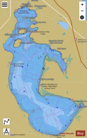

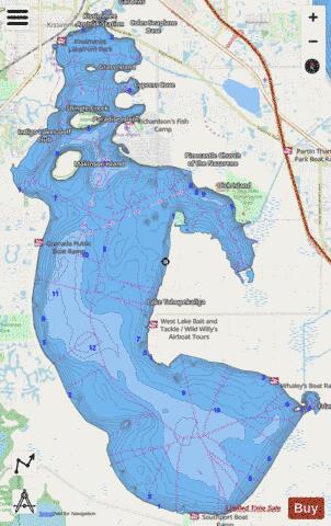
LAKE TOHOPEKALIGA Fishing Map Stats | |
| Title | LAKE TOHOPEKALIGA |
| Scale | 1:12000 |
| 1 ft Depth Contours for Anglers | Yes |
| Counties | Osceola |
| Nearby Cities | Kissimmee, Campbell, Saint Cloud, Poinciana, Intercession City, Narcoossee, Celebration, Taft, Loughman, Sky Lake |
| Area * | 19005.73 acres |
| Shoreline * | 54.79 miles |
| Min Longitude | -81.43 |
| Min Latitude | 28.14 |
| Max Longitude | -81.32 |
| Max Latitude | 28.30 |
| Edition Label 1 | |
| Edition Label 2 | |
| Edition Label 3 | |
| Id | US_FL_00292327 |
| Country | US |
| Projection | Mercator |
| * some Stats may include nearby/connecting waterbodies | |
|