Charlevoix, Lake fishing map is available as part of iBoating : USA Marine & Fishing App(now supported on multiple platforms including Android, iPhone/iPad, MacBook, and Windows(tablet and phone)/PC based chartplotter.).
With our Lake Maps App, you get all the great marine chart app features like fishing spots, along with Charlevoix, Lake depth map. The fishing maps app include HD lake depth contours, along with advanced features found in Fish Finder / Gps Chart Plotter systems, turning your device into a Depth Finder. The Charlevoix, Lake Navigation App provides advanced features of a Marine Chartplotter including adjusting water level offset and custom depth shading. Fishing spots and depth contours layers are available in most Lake maps. Lake navigation features include advanced instrumentation to gather wind speed direction, water temperature, water depth, and accurate GPS with AIS receivers(using NMEA over TCP/UDP). Autopilot support can be enabled during ‘Goto WayPoint’ and ‘Route Assistance’.
Now i-Boating supports Fishing Points in Charlevoix, Lake.
Have more questions about the Nautical Chart App? Ask us.
Fishing Info for Charlevoix, Lake
Lake Charlevoix (/ˈʃɑːrləvɔɪ/ SHAR-lə-voy) is a lake in Charlevoix County in the U.S. state of Michigan. It is the third largest inland lake in the state with a surface area of over 17,200 acres (70 km²) and 56 miles (90 km) of shoreline. The maximum depth in the main basin is 122 feet (37 m) and in the south arm, 58 feet (18 m). The lake's largest tributaries are the Jordan River, feeding into the south arm at East Jordan, and the Boyne River, flowing into the main basin from the east at Boyne City. Other significant tributaries include Horton, Stover, Porter, and Loeb Creeks. The outflow of Lake Charlevoix is the short Round Lake/Pine River complex which discharges into Lake Michigan at Charlevoix. The lake's watershed covers 335 square miles (870 km2) in Charlevoix and Antrim Counties, and a small portion of the northwest corner of Otsego County. The lake occupies portions of Charlevoix Township, Marion Township, Hayes Township, Eveline Township, Michigan, Bay Township, and Evangeline Township. Young State Park is located on the shore of the lake just northwest of Boyne City. The Ironton Ferry at Ironton, a designated Michigan Historical Site in operation since 1876, crosses the south arm where it branches off from the main basin, saving about 20 minutes of driving time around the south arm by the shoreline route. The lake was also known previously as Pine Lake and Long Lake. It was renamed from "Pine Lake" to its current name ("Lake Charlevoix") in 1926.
More on Wikipedia...Popular fish species in this lake include American brook lamprey, Bloater, Lake herring, Lake trout, Lake whitefish, Rainbow smelt, Rainbow trout, Rock bass, Sea lamprey, Smallmouth bass, Spoonhead sculpin, Threespine stickleback, White sucker and Yellow perch.
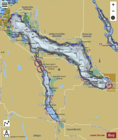
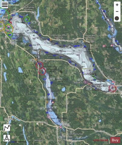
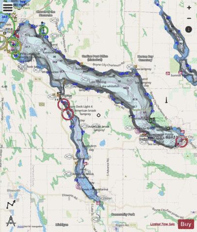
Charlevoix, Lake Fishing Map Stats | |
| Title | Charlevoix, Lake |
| Scale | 1:24000 |
| Includes Data from Fish Atlas | Yes |
| Counties | Charlevoix |
| Nearby Cities | Advance, Ironton, Boyne City, Horton Bay, East Jordan, Charlevoix, Bay Shore, Ellsworth, Walloon Lake, Boyne Falls |
| Area * | 17280.69 acres |
| Shoreline * | 60.11 miles |
| Min Longitude | -85.25 |
| Min Latitude | 45.15 |
| Max Longitude | -85.02 |
| Max Latitude | 45.33 |
| Edition Label 1 | |
| Edition Label 2 | |
| Edition Label 3 | |
| Id | US_MI_15_21 |
| Country | US |
| Projection | Mercator |
| * some Stats may include nearby/connecting waterbodies | |
|