Burt Lake fishing map is available as part of iBoating : USA Marine & Fishing App(now supported on multiple platforms including Android, iPhone/iPad, MacBook, and Windows(tablet and phone)/PC based chartplotter.).
With our Lake Maps App, you get all the great marine chart app features like fishing spots, along with Burt Lake depth map. The fishing maps app include HD lake depth contours, along with advanced features found in Fish Finder / Gps Chart Plotter systems, turning your device into a Depth Finder. The Burt Lake Navigation App provides advanced features of a Marine Chartplotter including adjusting water level offset and custom depth shading. Fishing spots and depth contours layers are available in most Lake maps. Lake navigation features include advanced instrumentation to gather wind speed direction, water temperature, water depth, and accurate GPS with AIS receivers(using NMEA over TCP/UDP). Autopilot support can be enabled during ‘Goto WayPoint’ and ‘Route Assistance’.
Now i-Boating supports Fishing Points in Burt Lake.
Have more questions about the Nautical Chart App? Ask us.
Fishing Info for Burt Lake
Burt Lake is a 17,120 acre (69 km2) lake in Cheboygan County in the U.S. state of Michigan. The western shore of the lake is on the boundary with Emmet County. The lake is named after William Austin Burt, who, together with John Mullett, made a federal survey of the area from 1840 to 1843. The lake is approximately 10 miles (16 km) long from north to south, about 5 miles (8 km) at its widest, and 73 feet (22 m) at its deepest. Major inflows to the lake are the Maple River, which connects with nearby Douglas Lake, the Crooked River, which connects with nearby Crooked Lake, the Sturgeon River which enters the lake near the point where the Indian River flows out of the lake into nearby Mullett Lake and the Little Carp River which enters on the northern end of the lake. The lake is part of the Inland Waterway, by which one can boat from Crooked Lake several miles (km) east of Petoskey on the Little Traverse Bay of Lake Michigan across the northern tip of the lower peninsula's so-called mitten to Cheboygan on Lake Huron. Along with nearby Mullett Lake and Black Lake, it is noted for its population of Lake Sturgeon, which briefly held the record of largest sturgeon caught in the USA. YMCA Camp Al-Gon-Quian and Burt Lake State Park are both located on the southern shore of the lake. The unincorporated community of Burt Lake is on the southwest shore on M-68. Interstate 75 passes to the east of the lake, with two interchanges near the south end of the lake at the unincorporated community of Indian River.
More on Wikipedia...Popular fish species in this lake include American brook lamprey, Blackchin shiner, Bluegill, Bluntnose minnow, Bowfin, Brown bullhead, Brown trout, Central mudminnow, Common shiner, Creek chub, Emerald shiner, Freshwater drum, Green sunfish, Iowa darter, Johnny darter, Lake herring, Largemouth bass, Longnose gar, Mimic shiner, Mottled sculpin, Ninespine stickleback, Northern logperch, Northern pike, Pumpkinseed, Rainbow trout, Rock bass, Sand shiner, Silver lamprey, Silver redhorse, Smallmouth bass, Spottail shiner, Trout-perch, Walleye, White sucker, Yellow bullhead and Yellow perch.
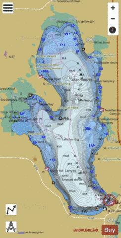
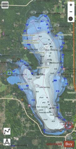
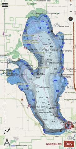
Burt Lake Fishing Map Stats | |
| Title | Burt Lake |
| Scale | 1:24000 |
| Includes Data from Fish Atlas | Yes |
| Counties | Cheboygan |
| Nearby Cities | Indian River, Topinabee, Brutus, Alanson, Ponshewaing, Pellston, Oden, Wolverine, Levering, Conway |
| Area * | 17403.88 acres |
| Shoreline * | 33.54 miles |
| Min Longitude | -84.73 |
| Min Latitude | 45.40 |
| Max Longitude | -84.62 |
| Max Latitude | 45.54 |
| Edition Label 1 | |
| Edition Label 2 | |
| Edition Label 3 | |
| Id | US_MI_16_193 |
| Country | US |
| Projection | Mercator |
| * some Stats may include nearby/connecting waterbodies | |
|