Houghton Lake fishing map is available as part of iBoating : USA Marine & Fishing App(now supported on multiple platforms including Android, iPhone/iPad, MacBook, and Windows(tablet and phone)/PC based chartplotter.).
With our Lake Maps App, you get all the great marine chart app features like fishing spots, along with Houghton Lake depth map. The fishing maps app include HD lake depth contours, along with advanced features found in Fish Finder / Gps Chart Plotter systems, turning your device into a Depth Finder. The Houghton Lake Navigation App provides advanced features of a Marine Chartplotter including adjusting water level offset and custom depth shading. Fishing spots and depth contours layers are available in most Lake maps. Lake navigation features include advanced instrumentation to gather wind speed direction, water temperature, water depth, and accurate GPS with AIS receivers(using NMEA over TCP/UDP). Autopilot support can be enabled during ‘Goto WayPoint’ and ‘Route Assistance’.
Now i-Boating supports Fishing Points in Houghton Lake.
Have more questions about the Nautical Chart App? Ask us.
Fishing Info for Houghton Lake
Houghton Lake is a lake in Roscommon County, Michigan. The unincorporated community of Prudenville is at the southeastern end of the lake, while the unincorporated communities of Houghton Lake and Houghton Lake Heights are on the southwest and west shores. It is the largest inland lake in the state of Michigan, and one of the largest natural inland lakes in the United States (many man-made impoundments are much larger). The lake is approximately 10 miles (16 km) north to south, and about 5+1⁄2 miles (8.9 km) at it widest point. Houghton Lake has c. 30 miles (48 km) of total shoreline and its waters cover 20,044 acres (81.12 km2). It is an extremely popular resort and fishing area year round. Houghton Lake is the site of Tip-Up-Town USA, a large ice fishing and winter sports festival with several events on the frozen waters of the lake itself. Houghton Lake is named after the first state geologist, Douglass Houghton who explored the area. Houghton County, in the Upper Peninsula of Michigan is also named after Douglass Houghton. The name of the lake is pronounced by Michigan citizens as "HOTE'n" (/ˈhoʊʔn̩/). The lake receives the waters of spring-fed Higgins Lake through the Cut River and, in turn, is the headwaters for the Muskegon River, which flows out of the North Bay in the northwest corner of the lake. The lake is partially within four townships: Markey Township on the northeast, Denton Township on the southeast, Roscommon Township on the southwest, and Lake Township on the northwest. The lake is mid to late mesotrophic in profile, and is considered to be a warm water, shallow lake, with the average depth being 7½ feet. The deepest spot is a small hole in East Bay that has been sounded to 22 feet (6.7 m), but it is rare to encounter depths of greater than 17 feet (5.2 m) in the lake. The lake offers almost every species of game and panfish found in Michigan with the exception of the trout/salmon families, the sturgeon, the muskellunge, and white bass. Common catches include northern pike, bluegill, walleye, crappie, yellow perch and both largemouth bass and smallmouth bass. M-55 follows the southern shore, while U.S. Highway 127 passes just to the west. M-18 and Interstate 75 pass just to the east. Houghton Lake is notable for the annual winter carnival, Tip Up Town USA, which is held during two consecutive weekends in January. The name for the festival originated from the flag-like devices - "tip-ups", used for ice fishing. The USA was added later. Tip Up Town Badges, required for entry to the Tip Up Town site on the south shore of Houghton Lake, are sold annually at local businesses.
More on Wikipedia...Popular fish species in this lake include Crappie, Lake sturgeon, Largemouth bass, Northern pike, Panfish, Smallmouth bass, Walleye, White bass and Yellow perch.
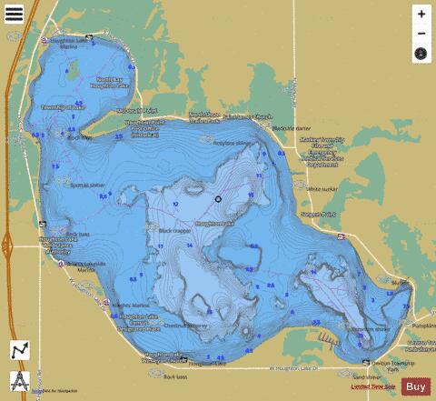
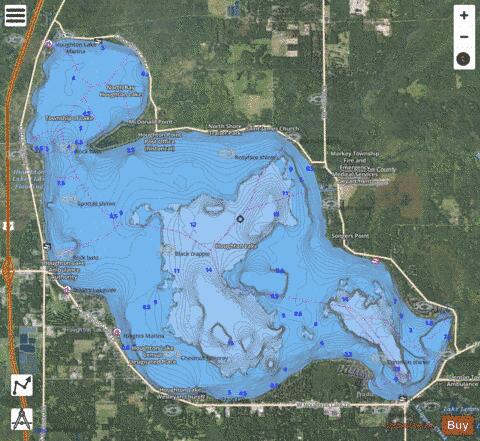
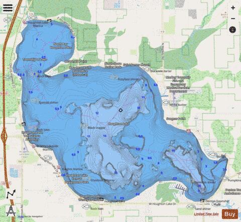
Houghton Lake Fishing Map Stats | |
| Title | Houghton Lake |
| Scale | 1:24000 |
| Includes Data from Fish Atlas | Yes |
| Counties | Roscommon |
| Nearby Cities | Prudenville, Houghton Lake, Roscommon, Moddersville, Saint Helen, Grayling, Harrison, Falmouth, Bear Lake, Gladwin |
| Area * | 20089.81 acres |
| Shoreline * | 35.90 miles |
| Min Longitude | -84.80 |
| Min Latitude | 44.30 |
| Max Longitude | -84.63 |
| Max Latitude | 44.40 |
| Edition Label 1 | |
| Edition Label 2 | |
| Edition Label 3 | |
| Id | US_MI_72_78 |
| Country | US |
| Projection | Mercator |
| * some Stats may include nearby/connecting waterbodies | |
|