Ten Mile fishing map is available as part of iBoating : USA Marine & Fishing App(now supported on multiple platforms including Android, iPhone/iPad, MacBook, and Windows(tablet and phone)/PC based chartplotter.).
With our Lake Maps App, you get all the great marine chart app features like fishing spots, along with Ten Mile lake depth map. The fishing maps app include HD lake depth contours, along with advanced features found in Fish Finder / Gps Chart Plotter systems, turning your device into a Depth Finder. The Ten Mile Navigation App provides advanced features of a Marine Chartplotter including adjusting water level offset and custom depth shading. Fishing spots and depth contours layers are available in most Lake maps. Lake navigation features include advanced instrumentation to gather wind speed direction, water temperature, water depth, and accurate GPS with AIS receivers(using NMEA over TCP/UDP). Autopilot support can be enabled during ‘Goto WayPoint’ and ‘Route Assistance’.
Now i-Boating supports Fishing Points in Ten Mile.
Have more questions about the Nautical Chart App? Ask us.
Fishing Info for Ten Mile
Ten Mile Lake is a lake located in north central Minnesota, United States. It is directly south of Walker and northwest of Hackensack. It is spring fed and is the deepest natural lake enclosed in Minnesota's borders. Ten Mile Lake covers over 5,046 acres (20.42 km2) with a maximum depth of 208 feet (63 m). It is known for its especially clear and clean water, due to the fresh spring sources. Ten Mile Lake was named for its distance, 10 miles (16 km) from the Indian agency on the Leech Lake Indian Reservation. Neighboring lakes include Portage Lake to the north, and Birch Lake to the south. Ten Mile Lake is also the headwaters of the Boy River, which flows downstream through Boy Lake, Woman Lake, and eventually into the Leech Lake River and finally the Mississippi River. This is a popular canoe and kayak route, since there are not many portages, and it can be done in just a few days. Most of the property around Ten Mile Lake is owned privately, but several resorts offer visitors a place to stay for short vacations.
More on Wikipedia...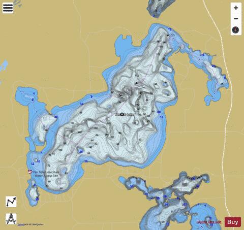

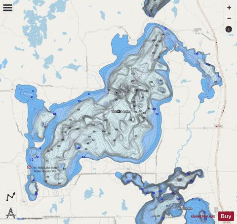
Ten Mile Fishing Map Stats | |
| Title | Ten Mile |
| Scale | 1:12000 |
| Counties | Cass |
| Nearby Cities | Hackensack, Walker, Akeley, Backus, Whipholt, Benedict, Nevis, Wilkinson, Laporte, Chickamaw Beach |
| Area * | 5049.03 acres |
| Shoreline * | 25.06 miles |
| Min Longitude | -94.62 |
| Min Latitude | 46.94 |
| Max Longitude | -94.52 |
| Max Latitude | 47.00 |
| Edition Label 1 | |
| Edition Label 2 | |
| Edition Label 3 | |
| Id | US_MN_11041300 |
| Country | US |
| Projection | Mercator |
| * some Stats may include nearby/connecting waterbodies | |
|