Lovell Lake fishing map is available as part of iBoating : USA Marine & Fishing App(now supported on multiple platforms including Android, iPhone/iPad, MacBook, and Windows(tablet and phone)/PC based chartplotter.).
With our Lake Maps App, you get all the great marine chart app features like fishing spots, along with Lovell Lake depth map. The fishing maps app include HD lake depth contours, along with advanced features found in Fish Finder / Gps Chart Plotter systems, turning your device into a Depth Finder. The Lovell Lake Navigation App provides advanced features of a Marine Chartplotter including adjusting water level offset and custom depth shading. Fishing spots and depth contours layers are available in most Lake maps. Lake navigation features include advanced instrumentation to gather wind speed direction, water temperature, water depth, and accurate GPS with AIS receivers(using NMEA over TCP/UDP). Autopilot support can be enabled during ‘Goto WayPoint’ and ‘Route Assistance’.
Now i-Boating supports Fishing Points in Lovell Lake.
Have more questions about the Nautical Chart App? Ask us.
Fishing Info for Lovell Lake
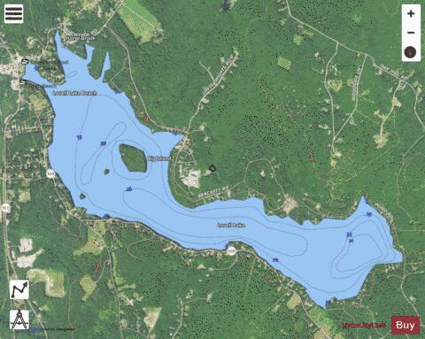
Lovell Lake is a 538-acre (2.18 km2) water body in Carroll County in eastern New Hampshire, United States, in the town of Wakefield. The lake is both spring-fed and fed by small streams including Horse Brook. The outlet of the lake, located at the village of Sanbornville, is the beginning of the Branch River. From here, the Branch River flows through Milton where it joins the Salmon Falls River on the Maine-New Hampshire border. The Salmon Falls River empties into the tidal waters of the Piscataqua River northwest of Portsmouth, New Hampshire, then into the Gulf of Maine. Lovell Lake is defined as a "Tier 1" water body and is designated as "fully supporting" according to the New Hampshire Department of Environmental Services. The Lovell Lake watershed covers 3,076 acres (1,244.8 ha). Its watershed is currently 64% forested, 14% developed, and contains 37% buildable area. The Lovell Lake shoreline is composed of primarily low density residential houses and camps (87%). The majority of these structures (68%) are within 50 feet (15 m) of the shoreline. Although the lake is designated as a high quality water lake, shoreline development and proximity of structures have led to increased polluted runoff that threatens the lake's water quality. Lovell Lake water quality has been measured since 1979 at station 1 and 1989 at station 2. This includes 19 years of secchi disk data (transparency), 19 years of phosphorus data, 16 years of chlorophyll-a (Chl-a) data, and 3 years of dissolved oxygen (DO) data. From this data, the median total phosphorus (TP) concentration in 2008 was 7.5 parts per billion (ppb) and mean secchi disk transparency was 6.3 m (20.7 ft). Several organizations are currently in place that aim to protect and improve the water quality of Lovell Lake. The Lovell Lake Association is dedicated to preserving the lake. Lovell Lake also has a courtesy boat inspection program run by the NH Lake Host Program that inspects over 500 boats annually. There is also a weed watchers program that searches the shores for invasive aquatic plants. The lake is classified as a warmwater fishery and contains rainbow trout, smallmouth and largemouth bass, chain pickerel, horned pout, white perch, and walleye.
More on Wikipedia...Popular fish species in this lake include Brown bullhead, Chain pickerel, Largemouth bass, Rainbow trout, Smallmouth bass and Walleye.
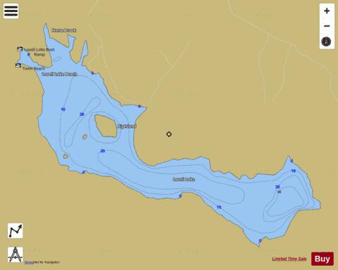
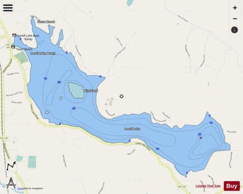
Lovell Lake Fishing Map Stats | |
| Title | Lovell Lake |
| Scale | 1:3000 |
| Counties | Carroll |
| Nearby Cities | Sanbornville, Wakefield, Brookfield, Milton Mills, Union, Acton, Milton, Shapleigh, Farmington, Ossipee |
| Area * | 553.77 acres |
| Shoreline * | 8.51 miles |
| Min Longitude | -71.03 |
| Min Latitude | 43.53 |
| Max Longitude | -70.98 |
| Max Latitude | 43.56 |
| Edition Label 1 | |
| Edition Label 2 | |
| Edition Label 3 | |
| Id | US_NH_00868188 |
| Country | US |
| Projection | Mercator |
| * some Stats may include nearby/connecting waterbodies | |
|