Eufaula_OK fishing map is available as part of iBoating : USA Marine & Fishing App(now supported on multiple platforms including Android, iPhone/iPad, MacBook, and Windows(tablet and phone)/PC based chartplotter.).
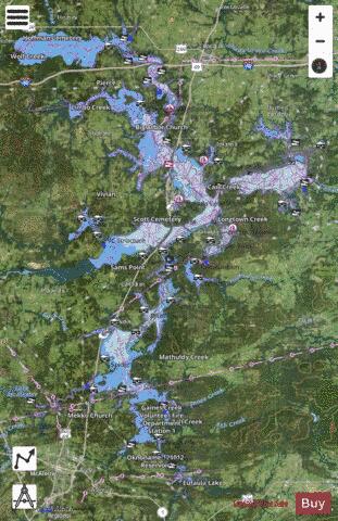
With our Lake Maps App, you get all the great marine chart app features like fishing spots, along with Eufaula_OK lake depth map. The fishing maps app include HD lake depth contours, along with advanced features found in Fish Finder / Gps Chart Plotter systems, turning your device into a Depth Finder. The Eufaula_OK Navigation App provides advanced features of a Marine Chartplotter including adjusting water level offset and custom depth shading. Fishing spots and depth contours layers are available in most Lake maps. Lake navigation features include advanced instrumentation to gather wind speed direction, water temperature, water depth, and accurate GPS with AIS receivers(using NMEA over TCP/UDP). Autopilot support can be enabled during ‘Goto WayPoint’ and ‘Route Assistance’.
Now i-Boating supports Fishing Points in Eufaula_OK.
Have more questions about the Nautical Chart App? Ask us.
Fishing Info for Eufaula_OK
Lake Eufaula, sometimes referred to as Eufaula Lake, is a reservoir in Oklahoma. It is located on the Canadian River, 27 mi (43 km) upstream from its confluence with the Arkansas River and near the town of Eufaula. The lake covers parts of McIntosh County, Pittsburg, Haskell and Okmulgee counties and drains 47,522 square miles (123,080 km2). Water sources include the Canadian, North Fork Canadian and Deep Fork rivers. It is the largest-capacity lake in the state of Oklahoma with a volume of 2,099,000 acre-feet (2.589×10⁹ m3), a surface area of 102,000 acres (410 km2) and 600 miles (970 km) of shoreline.
More on Wikipedia...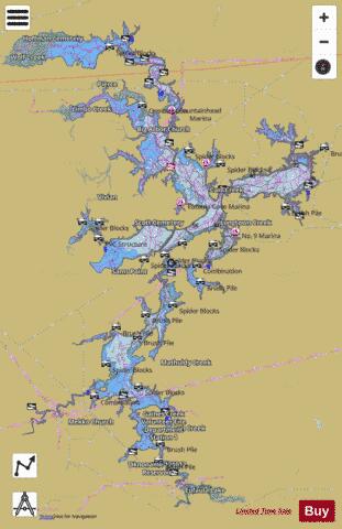
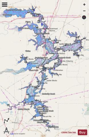
Eufaula_OK Fishing Map Stats | |
| Title | Eufaula_OK |
| Scale | 1:24000 |
| Counties | Haskell, McIntosh, Muskogee, Okmulgee, Pittsburg |
| Nearby Cities | Crowder, Eufaula, Canadian, Pierce, Stidham, Texanna, Hitchita, Blocker, Gowen, Hoffman |
| Area * | 108287.61 acres |
| Shoreline * | 768.13 miles |
| Min Longitude | -95.84 |
| Min Latitude | 34.89 |
| Max Longitude | -95.34 |
| Max Latitude | 35.52 |
| Edition Label 1 | |
| Edition Label 2 | |
| Edition Label 3 | |
| Id | US_TX_eufaula_ok |
| Country | US |
| Projection | Mercator |
| * some Stats may include nearby/connecting waterbodies | |
|