El Vado Reservoir fishing map is available as part of iBoating : USA Marine & Fishing App(now supported on multiple platforms including Android, iPhone/iPad, MacBook, and Windows(tablet and phone)/PC based chartplotter.).
With our Lake Maps App, you get all the great marine chart app features like fishing spots, along with El Vado Reservoir depth map. The fishing maps app include HD lake depth contours, along with advanced features found in Fish Finder / Gps Chart Plotter systems, turning your device into a Depth Finder. The El Vado Reservoir Navigation App provides advanced features of a Marine Chartplotter including adjusting water level offset and custom depth shading. Fishing spots and depth contours layers are available in most Lake maps. Lake navigation features include advanced instrumentation to gather wind speed direction, water temperature, water depth, and accurate GPS with AIS receivers(using NMEA over TCP/UDP). Autopilot support can be enabled during ‘Goto WayPoint’ and ‘Route Assistance’.
Now i-Boating supports Fishing Points in El Vado Reservoir.
Have more questions about the Nautical Chart App? Ask us.
Fishing Info for El Vado Reservoir
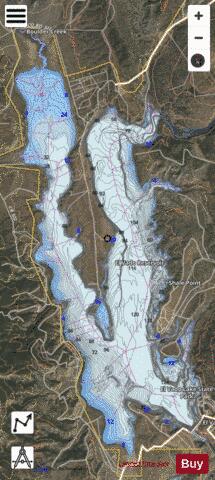
El Vado Lake is a reservoir located in Rio Arriba County, in northern New Mexico in the southwestern United States. Water is impounded by the earth-filled El Vado Dam, on the Rio Chama, 642 feet (196 m) long and 175 feet (53 m) high, completed in 1935. The 3,200-acre (13 km2) lake is 5 miles (8.0 km) long and over 1 mile (1.6 km) wide, and lies at an elevation of 6,900 feet (2,100 m). The eastern shore of the lake is the El Vado Lake State Park, featuring over 100 camping and picnic sites, and two improved boat ramps. The lake is a destination for salmon and trout fishing, as well as for boating. Unlike nearby Heron Lake, boat speeds are not restricted. A 5.5-mile (8.9 km) hiking trail runs to the north, crosses the Rio Chama Gorge via a pedestrian suspension bridge, and then connects to the Heron Lake State Park.
More on Wikipedia...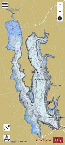

El Vado Reservoir Fishing Map Stats | |
| Title | El Vado Reservoir |
| Scale | 1:24000 |
| Counties | Rio Arriba |
| Nearby Cities | El Vado, Rutheron, La Puente, Los Ojos, Alire, Tierra Amarilla, Brazos, Ensenada, Monero, Cebolla |
| Area * | 3108.42 acres |
| Shoreline * | 29.97 miles |
| Min Longitude | -106.77 |
| Min Latitude | 36.59 |
| Max Longitude | -106.73 |
| Max Latitude | 36.67 |
| Edition Label 1 | |
| Edition Label 2 | |
| Edition Label 3 | |
| Id | US_UB_NM_el_vado |
| Country | US |
| Projection | Mercator |
| * some Stats may include nearby/connecting waterbodies | |
|