Long Lake fishing map is included in Alberta Lakes nautical charts folio. It is available as part of iBoating : Canada Marine & Fishing App (now supported on multiple platforms including Android, iPhone/iPad, MacBook, and Windows(tablet and phone)/PC based chartplotter. ).
With our Lake Maps App, you get all the great marine chart app features like fishing spots, along with Long Lake depth map. The fishing maps app include HD lake depth contours, along with advanced features found in Fish Finder / Gps Chart Plotter systems, turning your device into a Depth Finder. The Long Lake Navigation App provides advanced features of a Marine Chartplotter including adjusting water level offset and custom depth shading. Fishing spots and depth contours layers are available in most Lake maps. Lake navigation features include advanced instrumentation to gather wind speed direction, water temperature, water depth, and accurate GPS with AIS receivers(using NMEA over TCP/UDP). Autopilot support can be enabled during ‘Goto WayPoint’ and ‘Route Assistance’.
Now i-Boating supports Fishing Points in Long Lake.
Have more questions about the Nautical Chart App? Ask us.
Fishing Info for Long Lake
Long Lake is a lake in Thorhild County, in the Canadian province of Alberta, near Boyle, Alberta. The name of the lake is derived from the shape of the lake and has been used in the local area for many years. Long Lake has been used for recreational purposes throughout the twentieth century, with the establishment of Long Lake Provincial Park occurring in 1957.
More on Wikipedia...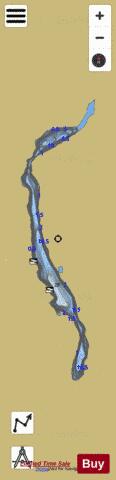

Long Lake Fishing Map Stats | |
| Title | Long Lake |
| Scale | 1:12000 |
| Districts | Division No. 13 |
| Nearby Cities | Athabasca, Redwater, Lamont, Lac la Biche, Gibbons, Fort Saskatchewan, Bon Accord, Legal |
| Area * | 1566.36 acres |
| Shoreline * | 18.99 miles |
| Min Longitude | -112.77 |
| Min Latitude | 54.39 |
| Max Longitude | -112.73 |
| Max Latitude | 54.50 |
| Edition Label 1 | |
| Edition Label 2 | |
| Edition Label 3 | |
| Id | CA_AB_long_lake__near_boyle___ab |
| Country | CA |
| Projection | Mercator |
| * some Stats may include nearby/connecting waterbodies | |
|