Magaguadavic Lake fishing map is included in New Brunswick Fishing Maps nautical charts folio. It is available as part of iBoating : Canada Marine & Fishing App (now supported on multiple platforms including Android, iPhone/iPad, MacBook, and Windows(tablet and phone)/PC based chartplotter. ).
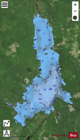
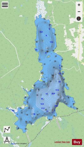
With our Lake Maps App, you get all the great marine chart app features like fishing spots, along with Magaguadavic Lake depth map. The fishing maps app include HD lake depth contours, along with advanced features found in Fish Finder / Gps Chart Plotter systems, turning your device into a Depth Finder. The Magaguadavic Lake Navigation App provides advanced features of a Marine Chartplotter including adjusting water level offset and custom depth shading. Fishing spots and depth contours layers are available in most Lake maps. Lake navigation features include advanced instrumentation to gather wind speed direction, water temperature, water depth, and accurate GPS with AIS receivers(using NMEA over TCP/UDP). Autopilot support can be enabled during ‘Goto WayPoint’ and ‘Route Assistance’.
Now i-Boating supports Fishing Points in Magaguadavic Lake.
Have more questions about the Nautical Chart App? Ask us.
Fishing Info for Magaguadavic Lake
Magaguadavic Lake (meaning "lake of eels" in Mi'kmaq) [pronounced: mack-a-dave-ick] is a lake in south-western New Brunswick, Canada. It lies primarily in Prince William Parish, but small parts of it extend into neighbouring Dumfries Parish and McAdam Parish, all in York County. The lake is home to smallmouth bass and landlocked salmon, and the warmer months see many fishermen, boaters, swimmers and vacationers throughout. Although not as massive as Grand Lake or Oromocto Lake, it is still one of the largest bodies of fresh water in New Brunswick. Part of the lake is known as "second lake" (also called "Little Magaguadavic" or "Little Mack"); this small inflow is connected via a winding, marshy channel called the thoroughfare. The larger of the "two" lakes is more commonly referred to as "Magaguadavic Lake" among residents and locals. There are many beaches and islands on both lakes.
More on Wikipedia...Popular fish species in this lake include Smallmouth bass.
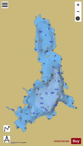
Magaguadavic Lake Fishing Map Stats | |
| Title | Magaguadavic Lake |
| Scale | 1:24000 |
| Nearby Cities | Starlight Village, St. Stephen, Woodstock, New Maryland, Fredericton, Saint Andrews, Oromocto |
| Area * | 6483.91 acres |
| Shoreline * | 39.32 miles |
| Min Longitude | -67.26 |
| Min Latitude | 45.67 |
| Max Longitude | -67.17 |
| Max Latitude | 45.77 |
| Edition Label 1 | |
| Edition Label 2 | |
| Edition Label 3 | |
| Id | CA_NB_magaguadavic_nb |
| Country | CA |
| Projection | Mercator |
| * some Stats may include nearby/connecting waterbodies | |
| ||||||||||||||||||||||||||||||||||||||||||||||||||||||||||||||||||||||||||||||||||||||||||||||||||||||||
|