Ouareau Lac fishing map is included in Quebec to Anticosti Island West nautical charts folio. It is available as part of iBoating : Canada Marine & Fishing App (now supported on multiple platforms including Android, iPhone/iPad, MacBook, and Windows(tablet and phone)/PC based chartplotter. ).
With our Lake Maps App, you get all the great marine chart app features like fishing spots, along with Ouareau Lac depth map. The fishing maps app include HD lake depth contours, along with advanced features found in Fish Finder / Gps Chart Plotter systems, turning your device into a Depth Finder. The Ouareau Lac Navigation App provides advanced features of a Marine Chartplotter including adjusting water level offset and custom depth shading. Fishing spots and depth contours layers are available in most Lake maps. Lake navigation features include advanced instrumentation to gather wind speed direction, water temperature, water depth, and accurate GPS with AIS receivers(using NMEA over TCP/UDP). Autopilot support can be enabled during ‘Goto WayPoint’ and ‘Route Assistance’.
Now i-Boating supports Fishing Points in Ouareau Lac.
Have more questions about the Nautical Chart App? Ask us.
Fishing Info for Ouareau Lac
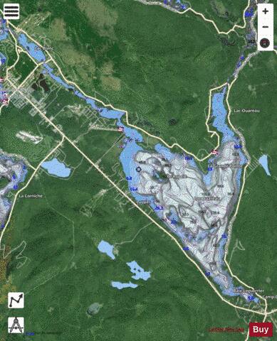
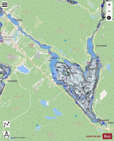
Lac (Lake) Ouareau is a fairly large lake located near the town of Saint-Donat, in Matawinie Regional County Municipality, Quebec, in administrative region of Lanaudière, in the province of Quebec, Canada. It is approximately 100 minutes by car north of downtown Montreal in the Laurentian Highlands and is located on the outskirts of Saint-Donat. Celine Dion currently owns a summer house on Lac Ouareau. Today, Archambault and Ouareau lakes receive thousands of vacationers who enjoy the many outdoor activities available in the region. The southwest shore of Lake Ouareau is served by the route 125 South which runs along the shore. The eastern part of the lake is served by the Saint-Guillaume path. The northern part (including the Baie de la Dame is served by the Ouareau North path. Recreational and tourist activities, notably vacationing, are the main economic activities in this area. The surface of Lake Ouareau is generally frozen from mid-December to the end of March; safe circulation on the ice is generally done from the end of December to the beginning of March.
More on Wikipedia...Popular fish species in this lake include Largemouth bass, Smallmouth bass and Yellow perch.
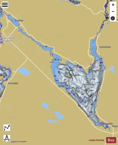
Ouareau Lac Fishing Map Stats | |
| Title | Ouareau Lac |
| Scale | 1:24000 |
| Districts | Matawinie |
| Nearby Cities | Saint-Donat-de-Montcalm, Sainte-Agathe-des-Monts - Val-David, Sainte-Adèle, Saint-Sauveur-des-Monts, Lac-Connelly, Terrasse-des-Pins, Saint-Michel-des-Saints, Filion, Saint-Jovite, Rawdon |
| Area * | 3533.79 acres |
| Shoreline * | 34.50 miles |
| Min Longitude | -74.22 |
| Min Latitude | 46.25 |
| Max Longitude | -74.11 |
| Max Latitude | 46.34 |
| Edition Label 1 | |
| Edition Label 2 | |
| Edition Label 3 | |
| Id | CA_QC_Ouareau_Lac_qc |
| Country | CA |
| Projection | Mercator |
| * some Stats may include nearby/connecting waterbodies | |
|