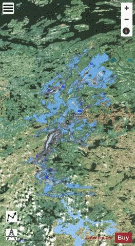
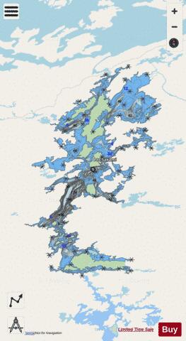
Sakami Lac fishing map is included in Quebec to Anticosti Island West nautical charts folio. It is available as part of iBoating : Canada Marine & Fishing App (now supported on multiple platforms including Android, iPhone/iPad, MacBook, and Windows(tablet and phone)/PC based chartplotter. ).
With our Lake Maps App, you get all the great marine chart app features like fishing spots, along with Sakami Lac depth map. The fishing maps app include HD lake depth contours, along with advanced features found in Fish Finder / Gps Chart Plotter systems, turning your device into a Depth Finder. The Sakami Lac Navigation App provides advanced features of a Marine Chartplotter including adjusting water level offset and custom depth shading. Fishing spots and depth contours layers are available in most Lake maps. Lake navigation features include advanced instrumentation to gather wind speed direction, water temperature, water depth, and accurate GPS with AIS receivers(using NMEA over TCP/UDP). Autopilot support can be enabled during ‘Goto WayPoint’ and ‘Route Assistance’.
Now i-Boating supports Fishing Points in Sakami Lac.
Have more questions about the Nautical Chart App? Ask us.
Fishing Info for Sakami Lac
Lac Sakami is a lake in the northwest of the province of Quebec in Canada. It is located east of James Bay, south of the Robert-Bourassa Reservoir and north of the Opinaca Reservoir. Lac Sakami is now a reservoir of the James Bay Project with a depth of 113 m (371 ft), an elevation of 186 m (610 ft) and an area of 738 km2 (285 sq mi). Prior to being used as a reservoir it had an area of 533 km2 (206 sq mi). The Cree called the lake Mesackamee.
More on Wikipedia...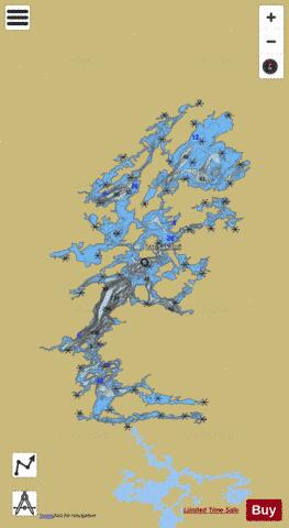
Sakami Lac Fishing Map Stats | |
| Title | Sakami Lac |
| Scale | 1:48000 |
| Districts | Nord-du-Québec |
| Area * | 143774.73 acres |
| Shoreline * | 894.81 miles |
| Min Longitude | -77.05 |
| Min Latitude | 52.95 |
| Max Longitude | -76.45 |
| Max Latitude | 53.50 |
| Edition Label 1 | |
| Edition Label 2 | |
| Edition Label 3 | |
| Id | CA_QC_Sakami_Lac__qc |
| Country | CA |
| Projection | Mercator |
| * some Stats may include nearby/connecting waterbodies | |
| |||||||||||||||||||||||||||||||||||||||||||||||||||||||||||||||||||||||||||||||||||||||||||||||||||||||
|