Carlyle / White Bear fishing map is included in Saskatchewan Fishing Maps nautical charts folio. It is available as part of iBoating : Canada Marine & Fishing App (now supported on multiple platforms including Android, iPhone/iPad, MacBook, and Windows(tablet and phone)/PC based chartplotter. ).
With our Lake Maps App, you get all the great marine chart app features like fishing spots, along with Carlyle / White Bear lake depth map. The fishing maps app include HD lake depth contours, along with advanced features found in Fish Finder / Gps Chart Plotter systems, turning your device into a Depth Finder. The Carlyle / White Bear Navigation App provides advanced features of a Marine Chartplotter including adjusting water level offset and custom depth shading. Fishing spots and depth contours layers are available in most Lake maps. Lake navigation features include advanced instrumentation to gather wind speed direction, water temperature, water depth, and accurate GPS with AIS receivers(using NMEA over TCP/UDP). Autopilot support can be enabled during ‘Goto WayPoint’ and ‘Route Assistance’.
Now i-Boating supports Fishing Points in Carlyle / White Bear.
Have more questions about the Nautical Chart App? Ask us.
Fishing Info for Carlyle / White Bear
White Bear (Carlyle) Lakeis a closed-basin lake in the Moose Mountain Upland. It is the largest lake on the plateau, slightly larger than its neighbour, Kenosee Lake. White Bear (Carlyle) Lake is within the White Bear 70 Indian reserve and Carlyle Lake Resort is along the southern shore. The lake and its amenities can be accessed from Highway 9. Originally the lake was named Carlyle Lake by the first European settlers to the area. In the late 1970s control of the lake was handed over to the White Bear First Nations and at that time the lake was renamed to White Bear (Carlyle) Lake.
More on Wikipedia...Popular fish species in this lake include Walleye.
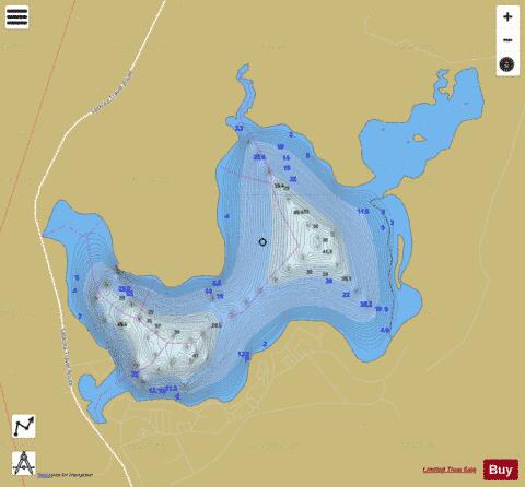
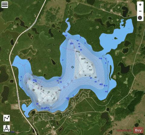
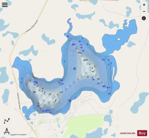
Carlyle / White Bear Fishing Map Stats | |
| Title | Carlyle / White Bear |
| Scale | 1:24000 |
| Nearby Cities | Carlyle, Oxbow, Moosomin, Carnduff, Esterhazy, Estevan |
| Area * | 2206.60 acres |
| Shoreline * | 17.19 miles |
| Min Longitude | -102.29 |
| Min Latitude | 49.76 |
| Max Longitude | -102.22 |
| Max Latitude | 49.80 |
| Edition Label 1 | |
| Edition Label 2 | |
| Edition Label 3 | |
| Id | CA_SK_Carlyle__see_White_Bear__sk |
| Country | CA |
| Projection | Mercator |
| * some Stats may include nearby/connecting waterbodies | |
|