Mistohay Lake fishing map is included in Saskatchewan Fishing Maps nautical charts folio. It is available as part of iBoating : Canada Marine & Fishing App (now supported on multiple platforms including Android, iPhone/iPad, MacBook, and Windows(tablet and phone)/PC based chartplotter. ).
With our Lake Maps App, you get all the great marine chart app features like fishing spots, along with Mistohay Lake depth map. The fishing maps app include HD lake depth contours, along with advanced features found in Fish Finder / Gps Chart Plotter systems, turning your device into a Depth Finder. The Mistohay Lake Navigation App provides advanced features of a Marine Chartplotter including adjusting water level offset and custom depth shading. Fishing spots and depth contours layers are available in most Lake maps. Lake navigation features include advanced instrumentation to gather wind speed direction, water temperature, water depth, and accurate GPS with AIS receivers(using NMEA over TCP/UDP). Autopilot support can be enabled during ‘Goto WayPoint’ and ‘Route Assistance’.
Now i-Boating supports Fishing Points in Mistohay Lake.
Have more questions about the Nautical Chart App? Ask us.
Fishing Info for Mistohay Lake
Mistohay Lake is a lake in Meadow Lake Provincial Park in the Canadian Province of Saskatchewan in the boreal forest ecozone of Canada. The lake is part of the Waterhen River drainage basin. The Waterhen River is a tributary of the Beaver River, which flows north into Lac Île-à-la-Crosse and the Churchill River, a major tributary in the Hudson Bay drainage basin. Several streams feed into Mistohay Lake, including ones that drain the southern slopes of the Mostoos Hills. Mistohay Creek, the lake's outflow, is located at the western end of the lake and it flows south-west into the Waterhen River. Shortly after Mistohay Creek leaves Mistohay Lake, it is met by another creek that drains nearby de Balinhard Lake. Highway 224 runs along the southern shore of the lake and provides access to the lake and the campground.
More on Wikipedia...Popular fish species in this lake include Northern pike and Walleye.
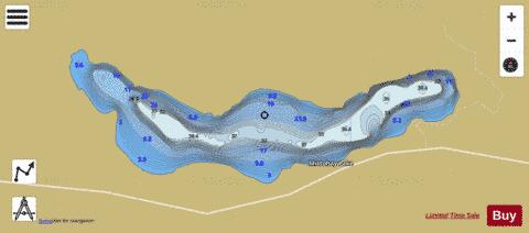

Mistohay Lake Fishing Map Stats | |
| Title | Mistohay Lake |
| Scale | 1:12000 |
| Nearby Cities | Meadow Lake |
| Area * | 1487.08 acres |
| Shoreline * | 9.96 miles |
| Min Longitude | -109.14 |
| Min Latitude | 54.45 |
| Max Longitude | -109.05 |
| Max Latitude | 54.47 |
| Edition Label 1 | |
| Edition Label 2 | |
| Edition Label 3 | |
| Id | CA_SK_Mistohay_Lake_sk |
| Country | CA |
| Projection | Mercator |
| * some Stats may include nearby/connecting waterbodies | |
|