Nipekamew Lake fishing map is included in Saskatchewan Fishing Maps nautical charts folio. It is available as part of iBoating : Canada Marine & Fishing App (now supported on multiple platforms including Android, iPhone/iPad, MacBook, and Windows(tablet and phone)/PC based chartplotter. ).
With our Lake Maps App, you get all the great marine chart app features like fishing spots, along with Nipekamew Lake depth map. The fishing maps app include HD lake depth contours, along with advanced features found in Fish Finder / Gps Chart Plotter systems, turning your device into a Depth Finder. The Nipekamew Lake Navigation App provides advanced features of a Marine Chartplotter including adjusting water level offset and custom depth shading. Fishing spots and depth contours layers are available in most Lake maps. Lake navigation features include advanced instrumentation to gather wind speed direction, water temperature, water depth, and accurate GPS with AIS receivers(using NMEA over TCP/UDP). Autopilot support can be enabled during ‘Goto WayPoint’ and ‘Route Assistance’.
Now i-Boating supports Fishing Points in Nipekamew Lake.
Have more questions about the Nautical Chart App? Ask us.
Fishing Info for Nipekamew Lake
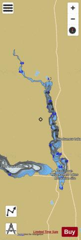
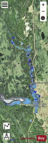
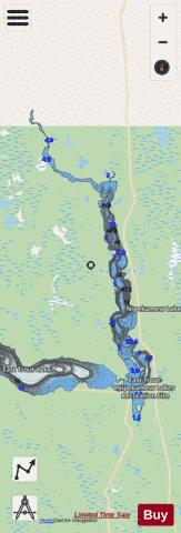
Nipekamew Lake is a lake in the Canadian province of Saskatchewan. The lake is north-east of Clarence-Steepbank Lakes Provincial Park and north-west of Narrow Hills Provincial Park and the Cub Hills. It is a long and narrow lake that runs in a north to south direction and is surrounded by boreal forest, rolling hills, and muskeg. The outflow, Nipekamew River, is at the northern end of the lake and at the southern end of the lake, neighbouring East Trout Lake flows directly into it through a short channel. Several other smaller rivers, such as Nipekamew Creek, also flow into the lake. The lake is part of the Churchill River watershed, which flows into the Hudson Bay. Nipekamew Lake is in the Northern Saskatchewan Administration District and is accessed from Highways 912 and 927. Highway 912 runs up along the eastern shore and Highway 927 goes to the southern end of the lake and heads west to East Trout Lake and services the resorts in the area.
More on Wikipedia...Popular fish species in this lake include Lake trout, Northern pike, Walleye and Yellow perch.
Nipekamew Lake Fishing Map Stats | |
| Title | Nipekamew Lake |
| Scale | 1:24000 |
| Nearby Cities | La Ronge |
| Area * | 3664.98 acres |
| Shoreline * | 41.81 miles |
| Min Longitude | -105.05 |
| Min Latitude | 54.34 |
| Max Longitude | -104.94 |
| Max Latitude | 54.51 |
| Edition Label 1 | |
| Edition Label 2 | |
| Edition Label 3 | |
| Id | CA_SK_nipekamew_lake__sk |
| Country | CA |
| Projection | Mercator |
| * some Stats may include nearby/connecting waterbodies | |
|