Parr Hill Lake fishing map is included in Saskatchewan Fishing Maps nautical charts folio. It is available as part of iBoating : Canada Marine & Fishing App (now supported on multiple platforms including Android, iPhone/iPad, MacBook, and Windows(tablet and phone)/PC based chartplotter. ).
With our Lake Maps App, you get all the great marine chart app features like fishing spots, along with Parr Hill Lake depth map. The fishing maps app include HD lake depth contours, along with advanced features found in Fish Finder / Gps Chart Plotter systems, turning your device into a Depth Finder. The Parr Hill Lake Navigation App provides advanced features of a Marine Chartplotter including adjusting water level offset and custom depth shading. Fishing spots and depth contours layers are available in most Lake maps. Lake navigation features include advanced instrumentation to gather wind speed direction, water temperature, water depth, and accurate GPS with AIS receivers(using NMEA over TCP/UDP). Autopilot support can be enabled during ‘Goto WayPoint’ and ‘Route Assistance’.
Now i-Boating supports Fishing Points in Parr Hill Lake.
Have more questions about the Nautical Chart App? Ask us.
Fishing Info for Parr Hill Lake
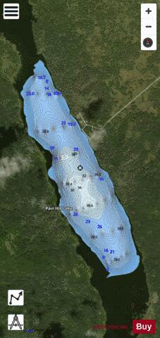
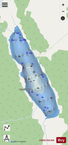
Parr Hill Lake, is a lake in the east-central part of the Canadian province of Saskatchewan in the boreal forest ecozone of Canada. It is part of the Swan River drainage basin and is situated in the Porcupine Hills and Saskatchewan's Porcupine Provincial Forest. A block of Porcupine Hills Provincial Park is on the north-eastern shore of the lake. The lake and park are accessed from Highway 982, which is also known as Little Swan Road. Parr Hill Lake sits in a glacier-formed valley in the Porcupine Hills and is fed by several small rivers and the surrounding muskeg. It is connected to Swan River via a short river that flows out of the south end of the lake. To the north of the lake, and in the same valley, is Pepaw Lake. While the lakes are in different river systems–Pepaw Lake flows north into Pepaw River and Parr Hill Lake flows south into Swan River–only a marshy portage separates the lakes.
More on Wikipedia...Popular fish species in this lake include Northern pike and Yellow perch.
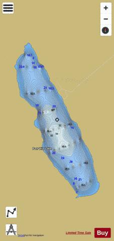
Parr Hill Lake Fishing Map Stats | |
| Title | Parr Hill Lake |
| Scale | 1:12000 |
| Nearby Cities | Hudson Bay, Canora, Kamsack, Swan River |
| Area * | 355.13 acres |
| Shoreline * | 4.11 miles |
| Min Longitude | -102.20 |
| Min Latitude | 52.36 |
| Max Longitude | -102.18 |
| Max Latitude | 52.38 |
| Edition Label 1 | |
| Edition Label 2 | |
| Edition Label 3 | |
| Id | CA_SK_parr_hill_lake__sk |
| Country | CA |
| Projection | Mercator |
| * some Stats may include nearby/connecting waterbodies | |
|