Pasqua Lake fishing map is included in Saskatchewan Fishing Maps nautical charts folio. It is available as part of iBoating : Canada Marine & Fishing App (now supported on multiple platforms including Android, iPhone/iPad, MacBook, and Windows(tablet and phone)/PC based chartplotter. ).
With our Lake Maps App, you get all the great marine chart app features like fishing spots, along with Pasqua Lake depth map. The fishing maps app include HD lake depth contours, along with advanced features found in Fish Finder / Gps Chart Plotter systems, turning your device into a Depth Finder. The Pasqua Lake Navigation App provides advanced features of a Marine Chartplotter including adjusting water level offset and custom depth shading. Fishing spots and depth contours layers are available in most Lake maps. Lake navigation features include advanced instrumentation to gather wind speed direction, water temperature, water depth, and accurate GPS with AIS receivers(using NMEA over TCP/UDP). Autopilot support can be enabled during ‘Goto WayPoint’ and ‘Route Assistance’.
Now i-Boating supports Fishing Points in Pasqua Lake.
Have more questions about the Nautical Chart App? Ask us.
Fishing Info for Pasqua Lake
Pasqua Lake is a lake along the course of the Qu'Appelle River in the Canadian province of Saskatchewan. Pasqua Lake was named after Chief Joseph Pasqua who formed what became the Pasqua First Nation. It is one of four lakes that make up the Fishing Lakes, which are all nestled in the Qu'Appelle Valley. The deep-cut Qu'Appelle Valley was formed about 14,000 years ago during the last ice age as meltwater from the glaciers carved out the valley. As water levels rose and fell, alluvium was left in the wake. These piles of alluvium are what created the separations between the lakes. Pasqua Lake is the farthest west and upstream of the four Fishing Lakes. The Qu'Appelle River enters the lake at the far western end and exits the lake at the eastern end through Sioux Crossing. Sioux Crossing is a short channel cut through the isthmus that separates Pasqua from Echo Lake. While the Qu'Appelle River is the primary inflow for the lake, other smaller creeks flow into the lake from the numerous coulees lining the lake's shore. Jumping Deer Creek is the only other named inflow and it flows into the lake at the north-east corner of the lake through the Pasqua Indian Reserve near Sioux Crossing. Highways 210 and 727 provide access to the lake.
More on Wikipedia...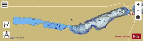
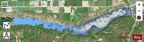
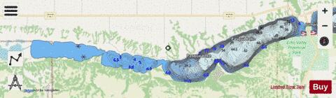
Pasqua Lake Fishing Map Stats | |
| Title | Pasqua Lake |
| Scale | 1:24000 |
| Nearby Cities | Fort Qu'Appelle, Balgonie, Indian Head, White City, Pilot Butte, Regina, Lumsden, Regina Beach, Foam Lake, Wynyard |
| Area * | 4618.71 acres |
| Shoreline * | 25.36 miles |
| Min Longitude | -104.13 |
| Min Latitude | 50.77 |
| Max Longitude | -103.90 |
| Max Latitude | 50.80 |
| Edition Label 1 | |
| Edition Label 2 | |
| Edition Label 3 | |
| Id | CA_SK_Pasqua_Lake_sk |
| Country | CA |
| Projection | Mercator |
| * some Stats may include nearby/connecting waterbodies | |
|