Redberry Lake fishing map is included in Saskatchewan Fishing Maps nautical charts folio. It is available as part of iBoating : Canada Marine & Fishing App (now supported on multiple platforms including Android, iPhone/iPad, MacBook, and Windows(tablet and phone)/PC based chartplotter. ).
With our Lake Maps App, you get all the great marine chart app features like fishing spots, along with Redberry Lake depth map. The fishing maps app include HD lake depth contours, along with advanced features found in Fish Finder / Gps Chart Plotter systems, turning your device into a Depth Finder. The Redberry Lake Navigation App provides advanced features of a Marine Chartplotter including adjusting water level offset and custom depth shading. Fishing spots and depth contours layers are available in most Lake maps. Lake navigation features include advanced instrumentation to gather wind speed direction, water temperature, water depth, and accurate GPS with AIS receivers(using NMEA over TCP/UDP). Autopilot support can be enabled during ‘Goto WayPoint’ and ‘Route Assistance’.
Now i-Boating supports Fishing Points in Redberry Lake.
Have more questions about the Nautical Chart App? Ask us.
Fishing Info for Redberry Lake
Redberry Lake is a lake near Hafford in the Canadian province of Saskatchewan. It is a medium-sized saline lake within an area characterized by mostly freshwater aquatic environments. The lake makes up the core protected area of the Redberry Lake (UNESCO) Biosphere Reserve, and is a federal bird sanctuary of the same name. A small regional park is situated at the north-west corner of the lake. The countryside surrounding Redberry Lake is typical of the aspen parkland biome of which it is a part.
More on Wikipedia...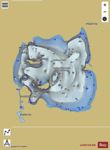
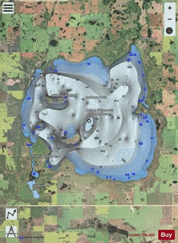
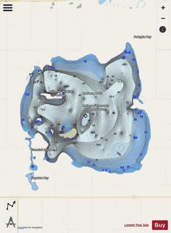
Redberry Lake Fishing Map Stats | |
| Title | Redberry Lake |
| Scale | 1:24000 |
| Nearby Cities | Langham, Dalmeny, Martensville, Warman, Osler, Saskatoon, Delisle, Rosthern, Shellbrook, Biggar |
| Area * | 12816.58 acres |
| Shoreline * | 35.43 miles |
| Min Longitude | -107.22 |
| Min Latitude | 52.64 |
| Max Longitude | -107.10 |
| Max Latitude | 52.73 |
| Edition Label 1 | |
| Edition Label 2 | |
| Edition Label 3 | |
| Id | CA_SK_redberry_lake__sk |
| Country | CA |
| Projection | Mercator |
| * some Stats may include nearby/connecting waterbodies | |
|