Walchensee fishing map is included in Germany - Bavaria Lakes nautical charts folio. It is available as part of iBoating : Inland Europe Marine & Fishing App (now supported on multiple platforms including Android, iPhone/iPad, MacBook, and Windows(tablet and phone)/PC based chartplotter. ).
With our Lake Maps App, you get all the great marine chart app features like fishing spots, along with Walchensee lake depth map. The fishing maps app include HD lake depth contours, along with advanced features found in Fish Finder / Gps Chart Plotter systems, turning your device into a Depth Finder. The Walchensee Navigation App provides advanced features of a Marine Chartplotter including adjusting water level offset and custom depth shading. Fishing spots and depth contours layers are available in most Lake maps. Lake navigation features include advanced instrumentation to gather wind speed direction, water temperature, water depth, and accurate GPS with AIS receivers(using NMEA over TCP/UDP). Autopilot support can be enabled during ‘Goto WayPoint’ and ‘Route Assistance’.
Have more questions about the Nautical Chart App? Ask us.
Fishing Info for Walchensee
Walchensee or Lake Walchen is one of the deepest and largest alpine lakes in Germany, with a maximum depth of 192.3 metres (631 ft) and an area of 16.4 square kilometres (6.3 sq mi). The lake is 75 kilometres (47 mi) south of Munich in the middle of the Bavarian Alps. The entire lake, including the island of Sassau, is within the municipality of Kochel. Landowner of the lake and island area is the Bavarian State. To the east and the south, the lake borders the municipality of Jachenau.
More on Wikipedia...Popular fish species in this lake include Alburnus mento, Asp (fish), Burbot, Common bleak, Common carp, Common roach, Common rudd, Esox, European bullhead, European eel, Ide (fish), Rainbow trout, Ruffe, Rutilus meidingerii, Salvelinus, Wels catfish and Zander.
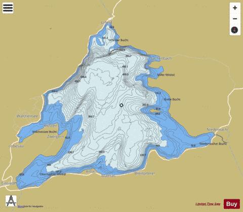
Walchensee Fishing Map Stats | |
| Title | Walchensee |
| Scale | 1:24000 |
| Area * | 3992.56 acres |
| Shoreline * | 18.54 miles |
| Min Longitude | 11.31 |
| Min Latitude | 47.57 |
| Max Longitude | 11.40 |
| Max Latitude | 47.62 |
| Edition Label 1 | |
| Edition Label 2 | |
| Edition Label 3 | |
| Id | II_DE_BY_walchensee |
| Country | Inland Europe |
| Projection | Mercator |
| * some Stats may include nearby/connecting waterbodies | |
|