Étang de Soulcem fishing map is included in France - Ariège Lacs nautical charts folio. It is available as part of iBoating : Inland Europe Marine & Fishing App (now supported on multiple platforms including Android, iPhone/iPad, MacBook, and Windows(tablet and phone)/PC based chartplotter. ).
With our Lake Maps App, you get all the great marine chart app features like fishing spots, along with Étang de Soulcem lake depth map. The fishing maps app include HD lake depth contours, along with advanced features found in Fish Finder / Gps Chart Plotter systems, turning your device into a Depth Finder. The Étang de Soulcem Navigation App provides advanced features of a Marine Chartplotter including adjusting water level offset and custom depth shading. Fishing spots and depth contours layers are available in most Lake maps. Lake navigation features include advanced instrumentation to gather wind speed direction, water temperature, water depth, and accurate GPS with AIS receivers(using NMEA over TCP/UDP). Autopilot support can be enabled during ‘Goto WayPoint’ and ‘Route Assistance’.
Have more questions about the Nautical Chart App? Ask us.
Fishing Info for Étang de Soulcem
Étang de Soulcem is a large artificial lake in the Pyrenees mountains in Ariège, France. It is at an elevation of 1570 m and is used for hydroelectricity, generating 62 GWh/year. The lake, which has a surface area of 0.91 km2, was formed following the construction by Électricité de France of a dam across the northern end of the Vicdessos valley in 1980–1983. The lake contains various fish including brown trout (S. trutta), Arctic char (S. alpinus), brook trout (S. fontinalis), and common minnow (P. phoxinus).
More on Wikipedia...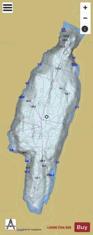
Étang de Soulcem Fishing Map Stats | |
| Title | Étang de Soulcem |
| Scale | 1:6000 |
| Area * | 213.73 acres |
| Shoreline * | 3.22 miles |
| Min Longitude | 1.44 |
| Min Latitude | 42.66 |
| Max Longitude | 1.45 |
| Max Latitude | 42.68 |
| Edition Label 1 | |
| Edition Label 2 | |
| Edition Label 3 | |
| Id | II_FR_L88_ECOGEA_20130801 |
| Country | Inland Europe |
| Projection | Mercator |
| * some Stats may include nearby/connecting waterbodies | |
|