Lochrutton Loch (Nith Basin) fishing map is included in Scotland - Dumfries and Galloway Lochs nautical charts folio. It is available as part of iBoating : Inland Europe Marine & Fishing App (now supported on multiple platforms including Android, iPhone/iPad, MacBook, and Windows(tablet and phone)/PC based chartplotter. ).
With our Lake Maps App, you get all the great marine chart app features like fishing spots, along with Lochrutton Loch (Nith Basin) lake depth map. The fishing maps app include HD lake depth contours, along with advanced features found in Fish Finder / Gps Chart Plotter systems, turning your device into a Depth Finder. The Lochrutton Loch (Nith Basin) Navigation App provides advanced features of a Marine Chartplotter including adjusting water level offset and custom depth shading. Fishing spots and depth contours layers are available in most Lake maps. Lake navigation features include advanced instrumentation to gather wind speed direction, water temperature, water depth, and accurate GPS with AIS receivers(using NMEA over TCP/UDP). Autopilot support can be enabled during ‘Goto WayPoint’ and ‘Route Assistance’.
Have more questions about the Nautical Chart App? Ask us.
Fishing Info for Lochrutton Loch (Nith Basin)
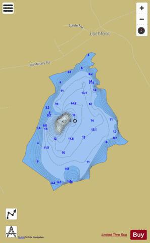
Lochrutton Loch is a large, lowland freshwater loch that lies to the west of Dumfries, Scotland. The loch trends from north to south and is 0.75 mi (1.21 km) long and 0.5 mi (0.80 km) at its widest point. It has an average depth of 13 ft (4.0 m) and is 58 ft (18 m) at its deepest. The loch was surveyed on 1 May 1905 by James Murray and L. W. Collett as part of Sir John Murray's Bathymetrical Survey of Fresh-Water Lochs of Scotland 1897-1909. In the centre of the loch are the remains of a crannog known as Dutton's cairn. It was excavated between 1901 and 1902 and found to have a circular cairn of earth, with a diameter of approximately 80 ft (24 m). The crannog is thought to date from the Early Iron Age and was occupied until the Middle Ages. Finds from the excavation included a jet cross dating from the 13th century. One of the areas adjacent to the loch is historically attested to have been known as 'Foot Ball Knowes' (knowe being the Scots for 'hillock'), possibly the only 'football' place name in Scotland, as early as 1815. The loch is populated with bream, perch, pike and roach. No permit is required to fish on the loch.
More on Wikipedia...Popular fish species in this lake include Northern pike.
Lochrutton Loch (Nith Basin) Fishing Map Stats | |
| Title | Lochrutton Loch (Nith Basin) |
| Scale | 1:6000 |
| Area * | 128.74 acres |
| Shoreline * | 2.17 miles |
| Min Longitude | -3.73 |
| Min Latitude | 55.03 |
| Max Longitude | -3.72 |
| Max Latitude | 55.04 |
| Edition Label 1 | |
| Edition Label 2 | |
| Edition Label 3 | |
| Id | II_SCOT_74400513_4_scot |
| Country | Inland Europe |
| Projection | Mercator |
| * some Stats may include nearby/connecting waterbodies | |
| |||||||||||||||||||||||||||||||||||||||||||||||||||||||||||||||||||||||||||||||||||||||||||||||||||||||
|