Loch Of Hundland fishing map is included in Scotland - Orkney Lochs nautical charts folio. It is available as part of iBoating : Inland Europe Marine & Fishing App (now supported on multiple platforms including Android, iPhone/iPad, MacBook, and Windows(tablet and phone)/PC based chartplotter. ).
With our Lake Maps App, you get all the great marine chart app features like fishing spots, along with Loch Of Hundland lake depth map. The fishing maps app include HD lake depth contours, along with advanced features found in Fish Finder / Gps Chart Plotter systems, turning your device into a Depth Finder. The Loch Of Hundland Navigation App provides advanced features of a Marine Chartplotter including adjusting water level offset and custom depth shading. Fishing spots and depth contours layers are available in most Lake maps. Lake navigation features include advanced instrumentation to gather wind speed direction, water temperature, water depth, and accurate GPS with AIS receivers(using NMEA over TCP/UDP). Autopilot support can be enabled during ‘Goto WayPoint’ and ‘Route Assistance’.
Have more questions about the Nautical Chart App? Ask us.
Fishing Info for Loch Of Hundland
The Loch of Hundland is a shallow freshwater loch in the parish of Birsay in the north west of the mainland of Orkney, Scotland. The loch lies between the larger lochs of Swannay and Boardhouse and acts as the main water catchment for Loch of Boardhouse. It has a great variety of aquatic plants including species that are unusual locally and nationally, and many types of birds including waders, gulls, larks and ducks that nest or use the loch. It is also popular for trout fishing. The loch was surveyed in 1906 by James Murray and later charted as part of the Bathymetrical Survey of Fresh-Water Lochs of Scotland 1897-1909.
More on Wikipedia...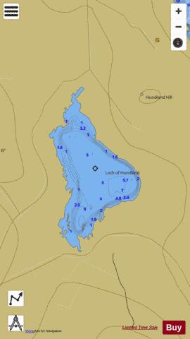
Loch Of Hundland Fishing Map Stats | |
| Title | Loch Of Hundland |
| Scale | 1:12000 |
| Area * | 248.99 acres |
| Shoreline * | 5.16 miles |
| Min Longitude | -3.24 |
| Min Latitude | 59.11 |
| Max Longitude | -3.22 |
| Max Latitude | 59.13 |
| Edition Label 1 | |
| Edition Label 2 | |
| Edition Label 3 | |
| Id | II_SCOT_74400544_2_scot |
| Country | Inland Europe |
| Projection | Mercator |
| * some Stats may include nearby/connecting waterbodies | |
| ||||||||||||||||||||||||||||||||||||||||||||||||||||||||||||||||||||||||||||||||||||||||||||||||||||||||
|