Loch Chon fishing map is included in Scotland - Stirling Lochs nautical charts folio. It is available as part of iBoating : Inland Europe Marine & Fishing App (now supported on multiple platforms including Android, iPhone/iPad, MacBook, and Windows(tablet and phone)/PC based chartplotter. ).
With our Lake Maps App, you get all the great marine chart app features like fishing spots, along with Loch Chon lake depth map. The fishing maps app include HD lake depth contours, along with advanced features found in Fish Finder / Gps Chart Plotter systems, turning your device into a Depth Finder. The Loch Chon Navigation App provides advanced features of a Marine Chartplotter including adjusting water level offset and custom depth shading. Fishing spots and depth contours layers are available in most Lake maps. Lake navigation features include advanced instrumentation to gather wind speed direction, water temperature, water depth, and accurate GPS with AIS receivers(using NMEA over TCP/UDP). Autopilot support can be enabled during ‘Goto WayPoint’ and ‘Route Assistance’.
Have more questions about the Nautical Chart App? Ask us.
Fishing Info for Loch Chon
Loch Chon is a freshwater loch situated west of the village of Aberfoyle, near the small village of Kinlochard, Stirling, Scotland, UK. Loch Chon lies upstream of Loch Ard and to the south of Loch Katrine. In the past, Loch Chon was known as Loch-a-Choin - loch of the dog/dogs. Choin is the Scots Gaelic word for dog in its genitive case (coin), lenited because loch is a masculine noun, causing an 'h' to be placed after the 'c'. It releases its water into the 4.5-kilometre (2.8 mi) long Water of Chon, which not far from the outlet passes Loch Dhu, and is the main affluent of Loch Ard. Loch Chon itself is fed by several small streams which can be considered to be the true sources of the River Forth. There are three islands in the loch. Two are unnamed, including the largest, which is roughly 315 feet/96 metres long. The medium sized island is called Heron Island and is roughly 230 feet/70 metres long.
More on Wikipedia...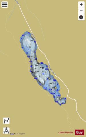
Loch Chon Fishing Map Stats | |
| Title | Loch Chon |
| Scale | 1:12000 |
| Area * | 262.76 acres |
| Shoreline * | 4.47 miles |
| Min Longitude | -4.56 |
| Min Latitude | 56.20 |
| Max Longitude | -4.53 |
| Max Latitude | 56.23 |
| Edition Label 1 | |
| Edition Label 2 | |
| Edition Label 3 | |
| Id | II_SCOT_74422109_0_scot |
| Country | Inland Europe |
| Projection | Mercator |
| * some Stats may include nearby/connecting waterbodies | |
| |||||||||||||||||||||||||||||||||||||||||||||||||||||||||||||||||||||||||||||||||||||||||||||||||||||||
|